Changes to the NCEP Meso Eta Analysis and Forecast System : Assimilation of observed precipitation, upgrades to land-surface physics, modified 3DVAR analysis
Eric Rogers Michael Ek* Ying Lin Kenneth Mitchell David Parrish Geoffrey DiMego
Mesoscale Modeling Branch and University Corporation for Atmospheric Research*
Environmental Modeling Center, National Centers for Environmental Prediction
1. Introduction
A series of changes to the NCEP Mesoscale Eta Analysis and Forecast System are described. These enhancements are designed to improve model performance by addressing known shortcomings in the Eta forecast model (such as biases in low-level temperature / relative humidity) and in the Eta 3-dimensional variational (3DVAR) analysis. The planned changes consist of the following:
1) Assimilation of observed precipitation during the Eta Data Assimilation System (EDAS) using the NCEP hourly precipitation analysis (Lin et al, 2001).
2) Changes to the Eta model land-surface physics (Ek et al., 2001) in the treatment of soil heat flux, canopy conductance, "bare" soil evaporation, and snowpack physics.
3) Modifications to the Eta 3DVAR analysis to improve the mass-wind balance constraint.
Each of the above components has been tested in a 22-km Eta retrospective run for a summer month (12 August-12 September 2000). Components 2 and 3 above have also been tested in a cold season (February 2001) Eta-22 retrospective. Since the assimilation of observed precipitation was tested in the EMC real-time Eta-22 parallel from 28 March - 16 May 2001 (in addition to the 48-km winter test described below), it was not rerun for the February 2001 period. Since the Meso Eta-22 was not implemented into production until 26 September 2000 (check date), the current operational 22-km Meso Eta was rerun for the August-September 2000 period. In addition, real-time 48-km parallel tests of each of the above have been performed:
- Precipitation assimilation : 15 February 2001 - 24 April 2001
- Land-surface physics : 25 April 2001 - present
- New 3DVAR analysis : 4 April 2001 - present
A detailed description of each component is presented below, accompanied by quantitative verification statistics and specific case studies.
2. Assimilation of hourly precipitation analyses
a. Rationale for assimilating precipitation data
When a 4-dimensional data assimilation system (4DDA) does not directly assimilate precipitation observations, the precipitation products typically exhibit significant systematic biases, stemming from shortcomings in the model. Such precipitation biases then degrade the quality of the other water cycle components in the 4DDA product suite. An example of these biases are shown in Fig. 1(a,c,d)
In 1996, NCEP developed an hourly, real-time 4km U.S. precipitation analysis (Baldwin and Mitchell, 1997). The analysis uses hourly precipitation estimates from the WSR-88D radar network, and the hourly reports from the approximately 2,500 automated rain gauges via the GOES Data Collection Platform. This product gives us the opportunity to assimilate precipitation observations in the mesoscale Eta model's 4-dimensional data assimilation system (4DDA), in order to improve the quality of
1) the 4DDA precipitation accuracy
2) the short-term Eta model precipitation forecast
3) the other water cycle components, such as soil moisture in the 4DDA and forecast product suite
In the past several years we have conducted extensive experiments to test and evaluation precipitation assimilation on the Eta model, and concluded that the precipitation assimilation greatly improves the model's precipitation field during the data assimilation period (and as a result, improves the soil moisture field), provides a modest improvement on precipitation forecasts, while having no negative impact on other model fields.
b. The precipitation assimilation method
Based on the method by Carr and Baldwin (1991), the essence of precipitation assimilation in the Eta data Assimilation System (EDAS) is to nudge model fields into greater consistency with observed precipitation field during the 12-hour pre-forecast data assimilation period.
To that end at each time step during EDAS, at each grid point where precipitation observations are available, we compare the model precipitation (Pmod ) against the observations (Pobs ) and make adjustments in the following way:
1) If Pmod > 0 but Pobs = 0: we take back the Pmod and the corresponding amount of latent heating from the model; adjust water vapor mixing ratio (qv) so the relative humidity (RH) remains unchanged; and reduce cloud water mixing ratio to no more than the minimum amount required to produce rain (qcmin).
2) If Pmod > Pobs > 0: we reduce the latent heat release in each precipitating layer by multiplying the latent heating profile by the factor of Pobs/Pmod; adjust qv as in the previous scenario, and in layers where precipitation is being produced, reduce cloud water proportionally but keep it above the qcmin.
3) If Pmod < Pobs: first check to see if convection is possible, if so, we shorten the convective time scale to accelerate convective precipitation production, with the goal of producing an amount (Pcnv) that equals to Pobs (but no greater than the maximum amount allowed by the convective parameterization).
After the convective adjustment, if Pcnv < Pobs (either because the profile is not convective, or the maximum possible convective precipitation is less than Pobs), then we perform a grid scale precipitation adjustment by comparing the model's original grid scale precipitation (Pgrd) against Pobs - Pcnv. The procedure is as follows:
i. If Pgrd > 0, we multiply the grid scale latent heating profile by the ratio (Pobs - Pcnv)/Pgrd, change the qc in the rain-producing layers by the same factor (but keep it above qcmin) and adjust the qv so RH remains unchanged.
ii. If Pgrd = 0, we create a layer of cloud (the upper and lower limits of the cloud layer is determined by the model's moisture profile and the amount of target grid scale precipitation) and a parabolic latent heating profile which corresponds to the target grid-scale precipitation production (Pobs - Pcnv). Within the cloud layer we created, RH is set to 80% and qc is set to no less than qcmin.
c. Test conducted and major findings
The precipitation assimilation has been tested extensively on the Eta/EDAS system in both real-time parallel and retrospective mode. Below is a partial list of runs that have been made:
1) 1-15 Jul 1998: 80km parallel and retrospective runs
2) One week 32-km retrospective run for the 25 Jan 2000 East Coast Blizzard case.
3) 1 Nov 2000 - 31 Mar 2001: 48-km real-time parallel test
4) 29 Mar - 30 Apr 2001: 22-km real-time parallel runs
5) 12 Aug - 12 Sep 2000: 22-km warm-season retrospective test
We find that precipitation assimilation has the following impacts on the model:
a) Significantly improves the model's precipitation field during EDAS, and as a result, has a positive impact on the soil moisture field (Fig. 1 and Fig. 2.).
b) Often has a significant positive impact on the first 6 hours' of the model's precipitation forecast (Fig.3).
c) Positive impact on precipitation forecasts 24h and beyond is observed sometimes, and the overall impact as measured by forecast skill scores is modestly positive (Fig. 4). A small positive impact is observed in the Blizzard case (Experiment 2; not shown).
d) In the winter, because both the radar estimates and the hourly gauges tend to show severe low biases in the snow, assimilation of these data caused the model to be too dry. So rather than forcing the model to confirm to the biased observations, we have decided to only perform the precipitation assimilation outside of areas of snow.
e) No negative impact is seen on the model's temperature, moisture and wind fields, when the model forecasts fields (from the control run and the run with precipitation assimilation) are verified against observations (Fig. 5).
Additional quantitative verification statistics can be found on-line at http://www.emc.ncep.noaa.gov/mmb/PPTASM/tests.html .
3. Changes to the Eta model land-surface parameterization
In the present era of modern NWP, the continuing achievement of ever improving NWP model prediction skill requires relatively balanced, simultaneous advances in several major complimentary specialties of NWP. These major specialties include 1) ingest of new observation types and observing systems (e.g. WSR-88D radars, surface wind profilers), 2) improved objective analysis techniques (e.g. variational analysis), 3) new data assimilation approaches (adjoint models, forward models, direct assimilation of radiances), 4) improved parameterization of diabatic physical processes (cloud microphysics, deep and shallow convection, PBL, surface heat and water fluxes), 5) higher spatial resolution horizontally and vertically, 6) improved numerical methods for the core model hydrodynamics, 7) improved diagnostic algorithms for obtaining derived quantities in post-processing, and 8) expanded validation tools and techniques.
By the mid-1990's, the advances in PBL parameterization physics and vertical PBL resolution in mesoscale models (e.g. Eta, MM5) had typically outstripped the ability of the lagging land-surface parameterization and initialization schemes to provide sufficiently reliable surface heat and moisture fluxes to drive, or force, the diurnal development of the attendant PBL scheme. Thus, EMC initiated a concerted land-surface focus in the early 1990's, jointly with like-minded external partners in the Global Energy and Water Cycle Experiment (GEWEX -- and GEWEX sub-components, such as GCIP, ISLSCP, and PILPS). This focus has resulted in a fairly regular series of upgrades to the land-surface physics and land-surface initialization in the operational Eta/EDAS, with the first in this series of upgrades taking place in late January 1996.
This first upgrade replaced the traditional slab "bucket model", and its attendant fixed field of annually-averaged surface wetness, with 1) a multi-layer soil-vegetation-snowpack land-surface model or LSM known as the OSU LSM (originally developed at Oregon State University by Mahrt and Pan (1984) and Pan and Mahrt (1987) and modified at NCEP by Chen et al (1996) for use in the Eta model) and 2) initial soil moisture and temperature states produced by the continuously cycled NCEP Global Data Assimilation System (GDAS), whose land-surface scheme had also been upgraded to a version of the OSU LSM. Subsequent advances to the OSU LSM by NCEP, in collaboration with its GEWEX partners, led to coining of the new name of the "NOAH" LSM. Subsequent Eta implementations to the "NOAH" LSM included incorporation of the NESDIS satellite-derived, NDVI-based high-resolution vegetation greenness database (Feb 97), empirical corrections to biases in the GDAS-supplied initial soil moisture (Feb 97), refinements to evaporation over snow and bare soil (Feb 98), an increase from two to four soil layers (Feb 98), and the use of the NESDIS, year-round, operational, daily 23-km Northern Hemisphere snow cover and sea ice analysis (Jun 98). Lastly, the most notable of the changes since the initial upgrade in Jan 96 was the implementation in Jun 98 of fully continuous self-cycling of EDAS/Eta land states (soil moisture and temperature), without soil moisture nudging. So for nearly three years (as of May 2001), the Eta initial soil moisture and temperature have been the sole product of the coupled land/atmosphere physics and cycling of the Eta/EDAS suite and its land surface forcing, especially precipitation and surface insolation.
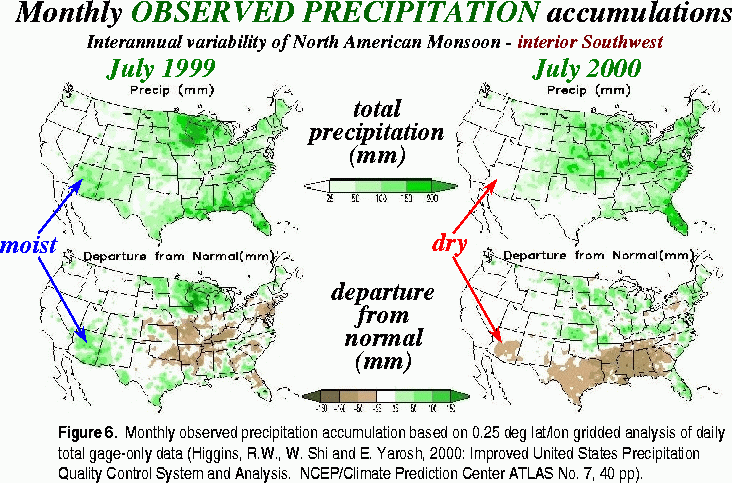
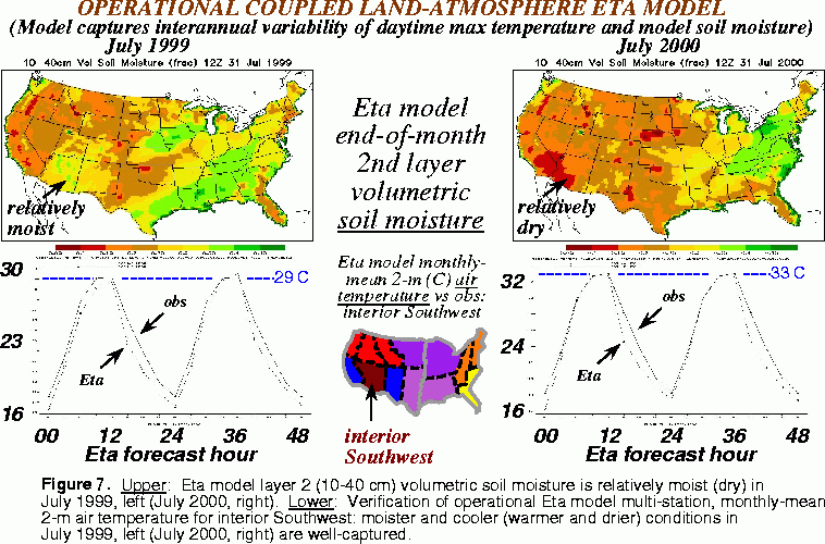
For the arid southwestern U.S. in summer, a current example of good near-surface Eta model forecast skill arising from the Eta coupling with the current NOAH LSM is given in Figs. 6 and 7. Fig. 6 shows the observed monthly total precipitation over the CONUS in July in 1999 (top left) and 2000 (top right), and their departures from monthly averages (bottom left and bottom right, respectively). Over the southwest U.S. monsoon region of Arizona, New Mexico, Utah, and Colorado, Fig. 6 shows that Jul 99 (Jul 00) was wetter (drier) than average. Fig. 7 shows the Eta model initial soil moisture at the end of Jul 99 (top left) and Jul 00 (top right), both products of the soil moisture cycling within the NOAH LSM component of the EDAS. Fig. 7 shows that over the southwest U.S. monsoon region, the EDAS soil moisture is relatively moist (dry) in Jul 99 (Jul 00), showing that the EDAS precipitation, and in turn the EDAS soil moisture, captured the essence of the interannual variability of the observed precipitation over this region. Most importantly, the bottom of Fig. 7 shows that the physics of the NOAH LSM coupled with the Eta model near-surface atmosphere 1) yielded virtually no bias in the monthly mean of the phase, daytime maximum, nighttime minimum, and amplitude of the 48-hour forecast versus of the diurnal cycle of 2-m air temperature, and 2) captured the interannual 2-m air temperature variability in this region, with cooler (warmer) monthly mean daytime temperature maximums of 29 C (33 C) in the wetter (drier) summer of Jul 99 (Jul 00).
Ideally, we desire and strive for the Eta/EDAS suite to achieve similar excellent skill in near-surface forecasts in other regions of the CONUS and other seasons of the year. However, the obstacles to this goal are the challenges of 1) modeling and initializing snowpack and frozen soil effects in the winter, 2) modeling the substantial surface effects of green vegetation in the warm season over the non-sparsely vegetated areas of the eastern half of the U.S., 3) regionally and seasonally varying biases in EDAS precipitation, and 4) regionally and seasonally varying biases in EDAS surface solar insolation. Factors 3) and 4) are most pronounced in the cloudy/rainy regions of the eastern half and northwestern U.S.
Hence like the other major parameterization schemes in the Eta model, such as cloud microphysics, convective parameterization, or radiation, we constantly develop and test incremental improvements -- in this case improvements to the NOAH LSM component of the Eta/EDAS suite to reduce near-surface forecast biases in temperature and humidity in all regions of the CONUS over all seasons. In the case of land surface parameterizations, the avenues toward incremental improvements can be grouped into the following 5 thrusts:
1) physics (add new physics, such as frozen soil, or refine existing physics such as snowmelt)
2) parameters (seek optimal values of empirical coefficients and exponents)
3) specifying land surface characteristics (e.g. albedo, or vegetation features such as root depth)
4) reducing biases in surface forcing from the atmospheric component of the Eta model
5) improving the land state initial conditions of soil moisture, soil temperature, and snowpack
The new EDAS assimilation of hourly radar/gage precipitation analyses already described in Section 2 represents a significant initiative in both thrusts 4 and 5 above.
The present section describes the positive impact from our recent NOAH LSM improvements in thrusts 1, 2), and 3) above. These improvements encompass the following:
A) refine the sub-surface heat flux formulations, including cold season under snowpack (following Lunardini, 1981), warm season under vegetation (following Peters-Lidard et al., 1997), and in extremes of wet and dry soil (following Peters-Lidard et al., 1998) (Thrust 1)
B) add the frozen soil, variable snow density, and patchy snowpack physics of our NWS/OHD collaborators (Koren et al, 1999) (Thrust 1)
C) refine an exponent of surface evaporation in the formulation for bare or sparsely vegetated soil surface to decrease the surface evaporation in the case of moist surface soil (Thrust 2)
D) adapt a higher value of the leaf area index parameter to increase transpiration for a given fraction of green vegetation (Thrust 2)
E) adapt a higher value of a parameter that strongly controls the dynamic calculation of the thermal roughness length for heat (the so-called Zilintichovich coefficient), which increases the aerodynamic resistance (Thrust 2)
F) develop and apply a global fixed field of the upper bound on surface albedo in the presence of deep snow. This field distinctly reflects the signatures of varying vegetation type and vegetation greenness and density (e.g. evergreen needle-leaf forests), as adapted from the work of Robinson and Kukla (1985) (Thrust 3)
G) adapt deeper rooting depths for all forest vegetation types to increase transpiration for a given fraction of green vegetation (Thrust 3)
The above initiatives were aimed at reducing the following known systematic biases in Eta forecasts of 2-m air temperature and humidity:
1) a cool bias over melting snowpack, especially in relatively warm southerly advection
regimes (Initiatives B, A, F)
2) a cool/moist bias over the typically moist early-spring soils before the rapid green-up of vegetation in late spring (Initiatives C, A, E)
3) a warm/dry bias in mid and late summer over the relatively dense green vegetation of the eastern half of the U.S. (Initiatives D, G)
In the next 3 subsections, we in turn demonstrate the positive impacts of our NOAH LSM changes on the systematic biases 1-3 above. All of the figures for these 3 sections are taken from the following web site (referred to below as "Site-N" for brevity) : http://lnx63.ncep.noaa.gov/NOAHLSM_test_dir/NOAHLSM_test.html . This site presents results from the following three retrospective and realtime parallel test periods:
a) retrospective parallel execution for the late winter month of Feb 01 (22 km resolution)
b) realtime parallel execution for mid-spring from 24 Apr to 15 May 01 (48-km resolution)
c) retrospective parallel execution for late summer from 12 Aug to 12 Sep 00 (22 km resolution)
For each of these test periods, the web site provides a distinct sub-section for each of the following four types of results comparing the operational and test version of the Eta model (with the new NOAH LSM):
1. Verification of 2-m T and RH, and 10-m wind for sub-regions spanning the CONUS
2. QPF equitable threat and bias scores for the CONUS
3. Individual synoptic case studies, with a focus on specific station meteograms
4. Upper air verification statistics against RAOBS
3.1 Reduction of near-surface cool bias over melting snowpack
The subject cool bias of this section is particularly evident over relatively shallow snowpacks underlying relatively warm air (e.g. well west of a cold, surface anticyclone center). We illustrate this bias, and its reduction in our test, with a case study focusing on Nebraska (and the reporting station of North Platte) and surrounding states in a 60-h Eta forecast initialized at 00Z on 02 Feb 01. This case is found at the "North Platte" link under the "Winter" column of Sec 3 of Site-N. Fig. 8 shows a left-right pair of successive NESDIS daily snow cover analyses (Ramsay, 1998) for the CONUS region, nominally valid at 18Z on 02 Feb and 03 Feb, with both showing snow cover over virtually all of Nebraska (including North Platte) on both days. Fig. 9 shows the ops (left) and test (right) color-shaded, 18-h Eta forecast of 2-m air T valid at 18Z (about noontime), each over-plotted with the same station-reported 2-m air T. The 2-m T over western Nebraska is virtually all below zero (above zero) in the ops (test) Eta forecast. The station-reported 2-m T shows that observed temperatures in western Nebraska are consistently above zero, as in the test Eta forecast. While the test Eta forecast represents a substantial improvement and shows a significant reduction of the cold bias, some cold bias is still evident in the test-case plot.
Figs. 10 and 11 show a 5-row set and 10-row set, respectively, of paired left/right frames depicting the hourly time series of 60-h Eta model forecasts (spanning from 00Z on 02 Feb to 12Z on 04 Feb) of various near-surface and surface variables at North Platte, NE, with the ops (test) Eta shown in the left (right) frame. (A definition of the 28 y-axis labels in these time series can be found by clicking on the "Key for figure" link) Fig. 10 shows the ops and test Eta forecast of 2-m T (1st row) and 2-m Td (2nd row) as dashed lines, and the station-reported 2-m T and Td as solid lines. The 2-m T forecast of the test Eta is clearly superior, showing substantially less mid-day cool bias and superior nighttime minimums. The 2-m Td forecast of the test Eta is also somewhat better, though room for improvement still remains.
The 3rd row of Fig. 11 shows the time series of forecast skin temperature, while the 7th row shows both the liquid-equivalent snowpack depth (dark blue curve) and the hourly accumulated snowmelt (light blue curve). Additionally, the 10th row shows both the surface sensible heat flux (FXSH, red) and the sub-surface heat flux (FXSS, blue), while the 9th row shows the surface latent heat flux, i.e. surface evaporation (FXLH, purple). These show that the LSM physics of the current Eta model strictly bounds the skin temperature at the freezing point during snowmelt, while the new LSM physics of the test Eta, which allows for patchy snow, allows the skin temperature to go above freezing during snow melt. Moreover, the test Eta allows more of the available incoming surface energy (net radiation) to go toward sensible heating and less toward both snow sublimation (surface evaporation) and snow melt. Hence, while the snowpack is completely melted during Day-1 in the ops Eta, the snowpack is still not completely melted during Day-2 of the test Eta, in agreement with the aforementioned NESDIS snow cover analysis on Day-2.
Finally, Fig. 12 shows the 24-h forecast (dashed curves) versus the verifying RAOB (solid curves) of the vertical profiles of T, Td, and wind vectors at North Platte, valid at 00Z on 03 Feb, with the ops (test) forecast in the left (right) frame. Scrutiny of the lowest 60 mb of these vertical profiles reveals that the observed RAOB depicts a surface temperature inversion over the snowpack. In the ops Eta forecast, this surface inversion is too deep and too cold, but is notably improved in the test forecast, being significantly less deep and less cold at the surface in the latter, though still overdone somewhat.
Sec. 1 of Site-N shows the monthly and areal mean 48-h Eta forecast versus station-observed diurnal cycle of 2-m T and RH and 10-m wind speed (squared). In each plot the solid, short-dashed, and long-dashed curves represent the observed, ops Eta, and test Eta, respectively. Inspection of the Feb 2001 results in Fig. 13 for the Western U.S. (more predominantly snow covered in February than the Eastern U.S.) shows a striking improvement in 2-m T in the test Eta, with a close match in monthly mean to the phase, amplitude, daytime max, and nighttime min of the observed 2-m T. The 2-m T of the test Eta also shows improvement, though less dramatic, in the Eastern U.S. for this Feb 2001 case. The 2-m RH (Fig. 14) is also clearly improved in the test Eta, showing a reduction of the positive RH bias, both in the west and east, though again more so in the west. This reduction in the positive RH bias likely reflects more the reduction in the 2-m temperature cold bias, rather than an improvement in the dew point bias. Finally, the 10-m wind speed (squared) (Fig 15) shows a small but acceptable degradation (about 1 m/s negative bias) in the test Eta in both the West and the East.
In Fig 16, the cold season (Feb 2001) results for the upper air verification (at the six standard pressure levels between 1000 and 300 mb) of temperature, height, relative humidity, and winds (all in terms of RMS error versus RAOBS) show that the test Eta yields the same or slightly smaller temperature, height, and wind errors, and notably smaller RH errors at the 850 and 1000 mb levels. Finally the CONUS-wide QPF threat and bias scores for the cold season in Fig 17 show virtually identical threat scores, and a slight improvement in bias.
3.2 Reduction of early spring near-surface cool/moist bias over central U.S.
The subject cool/moist bias of this section is particularly evident over the typically moist, early spring bare soils in the corn and wheat belts of the northern central plains and Midwest, after the melting of the winter snowpack and before the late-spring emergence of the cultivated crops. Hence, the evaporation in this situation is greatly dominated by direct evaporation from the upper soil surface, rather than from a) the snowpack as in winter, or from b) the crop canopy as in summer. (On the other hand, in the south central U.S., the green vegetation canopy is dominant, so transpiration from the vegetation will dominate direct evaporation from the soil in this region.) We illustrate the cool/moist bias over the northern tier states, and its reduction in our test, with a case study focusing on Illinois (and the reporting station of Champaign, IL) and surrounding states in a 60-hour Eta forecast initialized at 12Z on 27 Apr 01. This case is found at the "Champaign" link under the "Spring" column of Sec. 3 of Site-N.
Fig.18 shows the 60-h forecast, valid at 00Z Apr 30, of the vertically averaged dew point over the first 30-mb above the surface for the ops (test) Eta in the left (right) frame. A significant reduction of 2-m Td is evident throughout the north central U.S. in the test Eta versus the ops Eta, because change "C" decreases the direct evaporation from the soil surface, especially for moist soils, and change "A" decreases the sub-surface heat flux for moist soils, thus yielding more sensible heat flux, which forces a somewhat deeper and drier well-mixed PBL during the day. In the south central U.S., where transpiration dominates at this time of year, the 2-m Td is increased in the test Eta versus the ops Eta, because of changes D and G to increase transpiration.
For the same valid time as in Fig. 18, Fig.19 shows the ops (left) and test (right) color-shaded, 60-h Eta forecast of 2-m T (upper row) and 2-m Td (lower row), over-plotted corresponding station-reported values. The 2-m T over Illinois and its surrounding states is clearly warmer in the test Eta forecast and an obvious improvement, though some cool bias still remains, while the 2-m Td over this same area is clearly lower (drier) and notably better, though a moist bias still remains.
Figs. 20 and 21 have the same format as in Figs. 10 and 11, but now for the Champaign, IL surface reporting station. Here in this mid-spring, bare moist soil case, the 2-m T forecast of the test Eta is clearly superior, showing substantially less mid-day cool bias, by 3-4 oC, while maintaining the excellent performance of the ops Eta forecast for the nighttime minimums. The 2-m Td forecast of the test Eta is also somewhat better, though considerable room for improvement still remains. To further reduce the positive 2-m Td bias over and above that achieved in the test Eta here, we feel the diagnostic algorithm for 2-m Td must be re-formulated and this will be a key emphasis in our next phase of model development.
The last two rows of Fig. 21 show how the reduction in direct evaporation from bare soil in the test Eta has been manifested by a significant decrease (increase) in the day time surface latent heat flux (sensible heat flux). The decrease (increase) in latent (sensible) heat flux resulted in the decrease (increase) in 2-m Td (T) cited above in Figs. 18, 19, 20. Finally, following Fig. 12, Fig. 22 shows the comparison of the ops and test 36-h forecast of the RAOB profiles of T, Td, and wind vectors versus the verifying RAOB, valid at 00Z on 29 Apr. Scrutiny of the lowest 100 mb of these vertical profiles reveals that the test Eta forecast yields a warmer T-profile and drier Td-profile, which are clearly closer than the ops Eta to the observed profiles.
Since the Eastern U.S. is a mix of rather bare soils (sparse green vegetation) in the north and substantial green vegetation in the south, we must apply the option of smaller regional assessments at the bottom of Sec. 1 of Site-N for the Spring 2001 results. Separate inspection of 2-m T and Td results for the five regions of north central, south-central, northwest, southwest and northeast reveals that the 2-m T verification improvement is essentially neutral, while the 2-m RH verification is clearly improved in the test Eta case in all 5 regions, except the southwest (not shown, see Site-N for details).
In Sec. 4 of Site-N, the results for the upper air verification for the Spring 2001 case show that the test Eta yields virtually the same temperature, height, and wind errors, but meaningfully smaller RH errors at the 850 and 1000 mb levels. Lastly, the CONUS-wide QPF threat and bias scores for the spring season in Sec. 2 of Site-N show virtually identical threat and bias scores.
3.3 Reduction of late summer near-surface warm/dry bias over the eastern 2/3 of U.S.
The subject warm/dry bias of this section is particularly evident over the rather dry soils and dense green vegetation of late summer over the eastern � to two-thirds of the U.S. Given the substantial green vegetation, the evaporation in this situation is greatly dominated by transpiration through the plant canopy, and thus by soil moisture throughout the deep root zone.
All four sections of Site-N for the warm season case (Aug - Sep 00) show virtually neutral impact of the test Eta versus the ops Eta. We strongly suspect that the chief cause of the warm/dry bias of late summer is a dry soil moisture bias that arises from the continuous cycling of the EDAS, owing to a low bias in moderate to heavy precipitation amounts therein. Hence the most relevant evaluation of the warm season results awaits the mid-Aug to mid-Sep Eta test executions with all the changes of Sec. 2, 3, and 4 combined, especially the precipitation assimilation of Sec. 2.
4. New 3DVAR analysis
The upgrade to the Meso Eta system in September 2000 (Rogers et al, 2000) included a new 22 km version of the Meso Eta 3DVAR analysis that included 1) a rewrite of the computer code to take advantage of parallel infrastructure on the NCEP IBM-SP computer, 2) a new nonlinear quality control module and 3) the direct use of satellite radiances. Testing of this system in real-time during the summer of 2000 resulted in general praise of its guidance by forecasters, but resulted in somewhat reduced skill when measured against observations by objective verification. A rerun of January 2000 indicated satisfactory results and the changes were authorized with the proviso that the 3DVAR be retuned in time for the 2001 warm season. Before this retuning could be undertaken in earnest, events overtook us. These events were of a totally different character to anything seen in the January 2000 test period.
The significant positive impact of using NCEP Aviation model initial conditions for the 22 km Meso Eta forecast of the December 29-30, 2000 snow event (Rogers et al., 2001), combined with generally inconsistent performance of the Meso Eta relative to the aviation run for winter 2000-2001, resulted in a reevaluation of the Meso Eta 3DVAR analysis. A comparison yielded several features of the global 3DVAR that are different from the Meso Eta 3DVAR. First, the global 3DVAR analysis variables are divided into balanced and unbalanced components (using linear regression), as a means of obtaining approximate wind-mass balance in the analysis increment. The Meso Eta 3DVAR uses a weak geostrophic constraint to couple together full temperature and surface pressure increments to stream function increment. Second, the global 3DVAR analysis increment is defined directly in the model coordinate system. The Meso Eta 3DVAR computes the analysis increment on constant pressure surfaces with fewer vertical levels than the Meso Eta model, and also on a lower resolution unstaggered horizontal grid. The analysis increment is then interpolated to the Meso Eta grid in the horizontal and vertical and added to the guess. Finally, the global 3DVAR has a weak non-linear constraint which minimizes the difference between analysis and guess divergence tendency.
Table 1. Differences between old and new Meso Eta 3DVAR analysis
unbalanced: potential function,
temperature, surface pressure
Analysis Characteristic
Old Analysis
New Analysis Vertical representation
coarse fixed pressure levels
exact Meso Eta coordinate
levels Horizontal representation
coarse unstaggered grid
higher resolution unstaggered
grid Balance
weak geostrophic constraint
balanced variable separated
from unbalanced variables Analysis variables for wind
and mass
stream function, potential
function, temperature and
reference height
balanced: stream function
Background error
17 parameters
5 parameters
A significant difference still remains between the revised Meso Eta 3DVAR and the global 3DVAR. This is the weak constraint on divergence tendency, which is used in the global 3DVAR to minimize the difference between analysis and guess divergence tendency. In the Meso Eta 3DVAR, the weak constraint on the model time derivatives of divergence is not included because of difficulties with convergence, and the fact that using balanced and unbalances variables on the eta coordinate seems to cure the problem of poor dynamic balance. Instead of the full adjoint of the Eta model code, the linear shallow water equations linearize about a state of rest are used for the tangent linear model. It appears that the inclusion of balanced and unbalanced variables in the Meso Eta 3DVAR has resulted in a significant reduction in gravity wave noise in the EDAS (not shown).
For the past 4 months, changes have been incorporated and tested in the Meso Eta 3DVAR to address these differences (see Table 1). First, the vertical coordinate was changed from constant pressure to the exact Meso Eta model levels, and balanced and unbalanced variables were introduced, where the balanced variable relation was based directly on linear balance, and not a regression relationship. There are 16 adjustable parameters for the background error, defining variance and correlation lengths for the analysis variables. These needed to be redefined for the new analysis. Classical tuning by making large numbers of trial runs with different parameter values is very costly. We instead tried a new parameter estimation procedure (Purser and Parrish, 2000) which, in theory, should make parameter estimation much easier. A rerun of the December 29, 2000 storm using the new analysis (not shown) with the parameters from the new estimation method looked promising, so it was introduced into a parallel run. Unfortunately, after about a week, the forecasts degenerated considerably. Apparently the parameter estimation scheme gave poor results.
For the second phase of changes, it was decided to completely redefine the background error in a manner similar to the global 3DVAR system. The global 3DVAR background error variance, correlation lengths, and balanced-unbalanced relationships are defined from a one year set of 48 24hr forecast differences (being representative of the background error or error in the forecast). It was difficult to come up with a year's worth of Meso Eta forecasts because the forecast archive does not include the forecast on the Meso Eta computational grid, so a one year set of global T170 48-24hr forecast differences were generated and interpolated from sigma to Meso Eta in the vertical. From this set variances, correlation lengths and balance regression relationships were defined. The variances and balance regression relationships depend on latitude and vertical, while the vertical and horizontal correlation lengths depend only on the vertical. In this way, the number of adjustable parameters was reduced from 16 to 5, these being multipliers of the variance of stream function, potential function, unbalanced temperature, unbalanced surface pressure, and moisture. The correlation lengths are left fixed.
Once again, the parameter estimation scheme was used to find optimal values of the 5 amplitude parameters. However, results from a few days of assimilation (not shown) were again very disappointing. Apparently, the parameter estimation scheme overestimates the background variance amplitude parameters by an order of magnitude.
Since there are now only 5 parameters to adjust, and the moisture parameter is rather independent from the others for mass and wind, it was decided that hand tuning would be feasible. Several dozen experiments were run using an 80km version of the model, with all experiments over the same 2 days of assimilation. From these results, it was possible to select parameter values which produced acceptable results. Next, this was repeated for 48 km and 22 km, but initially for only 12 hours of assimilation. It was found that the same parameter values could be used with apparently similar results for all resolutions. Finally, six initial experiments were carried out with 3 days of assimilation for warm and cold season retrospective runs, from which further adjustments were made to the parameters. These numbers were introduced into the real-time 48 km parallel (started on 4 April 2001) and were used to start up the full 22-km resolution retrospective runs for winter (February 2001) and summer (August-September 2000).
Fig. 23 shows the quantitative precipitation forecast (QPF) skill scores (equitable threat and bias) over the contiguous United States for 22-km Meso Eta forecasts using the new 3DVAR analysis for the summer and winter retrospectives. For February 2000 the QPF skill was improved at all thresholds. The new 3DVAR analysis had less impact on QPF skill during the warm season test. Regional differences in QPF skill between the eastern and western U.S (not shown) were small for both the winter and summer retrospective tests.
Fig. 24 shows the vertical distribution of root-mean-square (RMS) vector wind, temperature, relative humidity and height error for 12, 36, and 60-h forecasts of the control Meso Eta-22 and the Eta-22 rerun with the new 3DVAR analysis for February 2001, while Fig. 25 shows the same results for August-September 2000. For both seasons the RMS errors are generally smaller using the new 3DVAR analysis, with the greatest impact seen in the winter retrospective test.
Quantitative verification statistics for the real-time 48-km test of the new 3DVAR analysis (started 4 April 2001, not shown) closely resemble the 22-km August-September 2000 results described above. Additional verification statistics for the new 3DVAR analysis can be found online at http://www.emc.ncep.noaa.gov/mmb/mmbpll/retroanl/3DVAR.html and http://sgi62.wwb.noaa.gov:8080/VSDB_PLL48/ .
An example of the performance of the new 3DVAR analysis can be seen from the
forecasts from the 00Z 15 February 2001 cycle shown in Figs. 26 and
27. Fig. 26 shows the 24-h forecast precipitation
from the operational Eta and the parallel Eta with the new 3DVAR analysis (ETAX) at 12Z 16 February and 12Z 17
February 2001 alongside the RFC precipitation analysis. For the 12-36 h forecast period, the ETAX
forecast extended the swath of heaviest precipitation (> 1 inch) from southcentral Texas northestwards into Kentucky,
while the operational Eta predicted a less widespread area of > 1 inch and extended amounts greater than 0.5
inches as far east as Maryland and Delaware. The ETAX forecast, although not perfect, is closer to the
RFC analysis.
Fig. 27 shows a series of 500 mb forecasts from the
operational Eta and parallel ETAX along with the NCEP Final analysis from 12Z 16 February - 12Z 17 February 2001.
At 12Z 16 February, the feature of interest is the short-wave trough over west Texas which progesses eastward
and weakens as it approaches the North Carolina coast by 12Z 17 February. Note that the operational
Eta forecast moved the short-wave too quickly eastward. The ETAX run using the new 3DVAR analysis did a much better
job in predicting the speed and strength of the short-wave as it approached the coast.
5. Conclusions
Both real-time and retrospective parallel tests of the full change package will begin as this
bulletin is being written. Quantitative skill scores and specific cases will be available on-line at
http://www.emc.ncep.noaa.gov/mmb/mmbpll/spring2001/bundle.html . The target date for this implementation (pending formal
approval by CAFTI) is on or about 26 June 2001.
REFERENCES Baldwin, M. E., and K.E. Mitchell, 1997: The NCEP hourly multi-sensor U.S. precipitation
analysis for operations and GCIP research. Preprints, 13th AMS Conference on Hydrology,
Long Beach, CA, 54--55. Carr, F. H., and M. E. Baldwin, 1991: Assimilation of observed precipitation data using NMC's
Eta model. Preprints, 9th AMS Conference on Numerical Weather Prediction, Denver, CO,
422-425. Chen, F., K. Mitchell, J. Schaake, Y. Xue, H. Pan, V. Koren, Q. Duan, M. Ek, and A. Betts,
1996: Modeling of land surface evaporation by four schemes and comparison with FIFE
observations. J. Geophys. Res., 101, 7251-7268. Ek, M., K. E. Mitchell, V. I. Koren, J. C. Schaake, Q. Duan, D. Lohmann, P. Grunmann, E.
Rogers, T. Black, C. Marshall, C. Peters-Lidard, and T. Meyers, 2001 : Spring 2001 changes
to the NCEP Eta Analysis and Forecast System : NOAH land-surface Model. 9th Conference
on Mesoscale Processes, Fort Lauderdale, FL. Koren, V., J. Schaake, K. Mitchell, Q. Duan, F. Chen, and J. Baker, 1999: A parameterization of
snowpack and frozen ground intended for NCEP weather and climate models. J. Geophys.
Res., 104, 19569-19585. Lin, Y., M. E. Baldwin, K. E. Mitchell, E. Rogers, and G. J. DiMego, 2001 : Spring 2001
changes to the NCEP Eta Analysis and Forecast System : Assimilation of observed
precipitation. 18th Conference on Weather Analysis and Forecasting and the 14th
Conference on Numerical Weather Prediction, Fort Lauderdale, FL. Lunardini, V. J., 1981: Heat Transfer in Cold Climates. Van Nostrand Reinhold Co., New
York, 731 pp. Mahrt, L. and H.-L. Pan, 1984: A two-layer model of soil hydrology. Bound.-Layer Meteorol.,
29, 1-20. Pan, H.-L., and L. Mahrt, 1987: Interaction between soil hydrology and boundary-layer
development. Bound.-Layer Meteorol., 38, 185-202. Peters-Lidard, C. D.,
E. Blackburn, X. Liang, and E. F. Wood, 1998: The effect of soil thermal
conductivity parameterization on surface energy fluxes and temperatures. J. Atmos. Sci., 55, Peters-Lidard, C. D., M. S. Zion, and E. F. Wood, 1997: A soil-vegetation-atmosphere transfer
scheme for modeling spatially variable water and energy balance processes. J. Geophys. Res.,
102, 4303-4324. Purser, R. J., and D. F. Parrish, 2000: A Bayesian technique for estimating continuously varying
statistical parameters of a variational assimilation. NCEP Office Note 429, 28pp. Ramsay, B. H., 1998: The interactive multisensor snow and ice mapping system. Hydrol.
Process., 12, 1537-1546. Robinson, D. A., and G. Kukla, 1985: Maximum surface albedo of seasonally snow-covered
lands in the northern hemisphere. J. Clim. Appl. Meteorol., 24, 402-411. Rogers, E., T. Black, W. Collins, G. Manikin, F. Mesinger, D. Parrish and G. DiMego, 2000:
Changes to the NCEP Meso Eta Analysis and Forecast System : Assimilation of satellite
radiances and increase in resolution. NWS Technical Procedures Bulletin 473, NOAA/NWS.
[ Available at
http://sgi62.wwb.noaa.gov:8080/ETA22TPB/ and from the National Weather
Service, Office of Meteorology, 1325 East-West Highway, Silver Spring, MD, 20910 ] Rogers, E., G. Manikin, and K. Brill, 2001 :Experiments with the NCEP Eta model for the 30-31
December 2000 East Coast Snowstorm: Sensitivity to initial conditions and sea surface
temperature. Preprints, 18th Conference on Weather Analysis and Forecasting and the 14th
Conference on Numerical Weather Prediction, Fort Lauderdale, FL.