

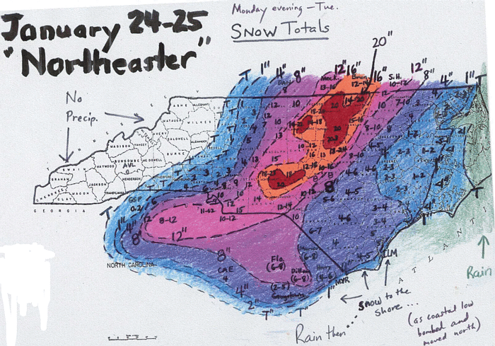
The local forecast issued at 21Z on 1/24/00 called for a 40% chance of light snow in Washington, DC the following morning. This was changed drastically 6 hours later when radar indicated that heavy snow was moving rapidly north into southern Virginia. After playing catchup on the issue of occurrence of snow, the forecasters then played catchup with predicting amounts. Here is the DC area snowfall analysis from the NWS in Sterling, Va, a North Carolina snowfall analysis from the office in Raleigh, NC, and an analysis for southern Virginia from the NWS in Wakefield, VA.
Satellite images on the 24th indicated that the trough over the southeast U.S. was taking on negative tilt. Here is a water vapor loop from Monday the 24th. Here is a visible image showing the storm as it moved up the east coast with a pronounced dry slot containing embedded convective cells.
The trend for the Eta was to track the precipitation shield further west with each run. Click here to see the precip forecast from the 00Z, 12Z, and 18Z runs on the 24th and the 00Z run on the 25th. Note that the output is displayed on the rather coarse Eta 104 grid (about 85-90 km resolution); click here to verify that the choice of output grid is not critical to the analysis of this case.
This trend in the precipitation shield occurred because the model began tracking the center of surface low pressure further to the west with each run. Click here to see the trends in the sea level pressure forecasts.
At least part of the difficulty in predicting the evolution of this storm was related to the forecasts of the evolution of the upper pattern. A short wave over the southeast carved out a strong upper low that moved up the east coast as opposed to the earlier solutions of a weaker wave passing well off the coast. Click here to see how the Eta runs did in predicting the evolution of the 500 mb height field along the east coast. Click here to see the picture of the major problems further upstream at 500 mb.
Again, the key model cycle for the forecasters producing the afternoon update was the 12Z on the 24th. The NGM produced guidance for this storm that was worse than the Eta. Click here to see how the NGM had the storm even further east. The AVN, on the other hand, was much closer to the Eta solutions for each run. Click here to see highlights from the 12Z and 18Z 1/24 AVN runs. The RUC2 offered an opporunity to compare the early hours of the other models' forecasts on the 24th. Click here to see output from the RUC2 forecasts.
Initial checks of the initializations of the models indicates some issues with upper-level winds over the southeast U.S. Click here to see initial findings on how the models incorporated observations into their forecasts.
|
Going back a few days, There was significant indication of a a major east coast storm for the week, but the indications were that the threat day would be Wednesday. Click here to see that the preceding runs of the MRF had significant problems with the 500 mb pattern verifying on the morning of the 24th.
|
Work is underway to help determine why the models had such difficulty in accurately predicting this event. The Eta model will be rerun with changes to the initialization, the convective scheme, cloud processes, and resolution. Forecasts from these tests will be added to this site as they become available.
The following 32-km Eta reruns have been made for the 12Z cycle on January 24:
|