5.7 Symp. on Observing and Understanding
the Variability of Water in Weather and Climate,
AMS Annual Meeting, Long Beach, CA, Feb. 2003
NCEP REGIONAL REANALYSIS
Fedor Mesinger*, Geoff DiMego+,
Eugenia Kalnay# (PIs), Perry Shafran~, Wesley Ebisuzaki^, Yun Fan¬, Robert
Grumbine+, Wayne Higgins^, Ying Lin+, Kenneth Mitchell+, David Parrish+, Eric
Rogers+, Wei Shi¬, Diane Stokes+, and Jack Woolen~
* NCEP/EMC and UCAR; + NCEP/EMC; #
Univ. Maryland; ~ NCEP/EMC and SAIC; ^ NCEP/CPC;
¬ NCEP/CPC and RSIS
Revised, 23 October 2002
1.
Introduction
The objective of the
NCEP’s Regional Reanalysis (RR) is to create a long-term set of consistent
climate data on a regional scale, for the North American domain. The RR, on its domain, will be superior to
the completed NCEP/NCAR Global Reanalysis (GR), in both resolution and
accuracy. This will be achieved using
the GR to drive the RR system, and taking advantage of the regional Eta Model,
and of the various advances that have been made in regional modeling and data
assimilation since the GR system starting time of 1995. These advances include assimilation of
precipitation, direct assimilation of radiances, the use of additional data as
well as improved data processing efforts, and several Eta Model developments,
in particular those arrived at within the NCEP’s GCIP-funded land-surface
effort.
One of the expectations
is that the RR will help answering questions of the variability of water in
weather and climate, in particular as it concerns U.S. precipitation
patterns. To that end, a special effort
will be made to output all native grid time-integrated quantities of water and
energy budgets. The RR should have a
good handle on extreme events, such as floods and droughts, and should
interface with hydrological models as well.
Results of preliminary
pilots, produced at 80-km horizontal resolution and 38 layers in the vertical,
have been inspected in a variety of ways, as well as reported on at several
meetings (e.g., Mesinger et al. 2002a).
The assimilation of precipitation during the reanalysis was found to be
very successful, obtaining model precipitation quite similar to the analyzed
precipitation, especially during the warmer seasons. In the 1998 pilot, temperature and vector wind rms fits to raobs
were considerably improved over those of the GR throughout the troposphere,
both in January and in July, and both in the analyses and in the first guess
fields. Improvements in the 2 m
temperatures and 10 m winds were seen as well.
We here report on our
first tentative production results, at 32 km/45 layer resolution. At the time of this writing preliminary
production run is in progress, even though some final changes are still being
worked on, so that the 32-km reanalysis so far done, the second half of 1987
and the first half of 1988, is being rerun at this time, and will be rerun once
again when the system is frozen. It is
planned to complete most of the 25 years of RR, 1979-2003, before the end of
2003. Once the 25 years are completed,
the RR will continue to be run in real-time, like the “Climate Data
Assimilation System” is being run as a real-time continuation of
____________________________________
*
Corresponding author address: Fedor Mesinger, NCEP Environmental Modeling
Center, 5200 Auth Road, Room 207, Camp Springs, MD 20746-4304; e-mail:
fedor.mesinger@noaa.gov
the GR. Just as the GR, the final
product is planned to contain also free forecasts at regular intervals, useful
for predictability studies.
The project is supported by the
NOAA Office of Global Programs (OGP), and at the time of this writing has just
completed its 4th year of support, thus having ended its Development
Stage. An 11 member Scientific Advisory
Panel chaired by John Roads provides advice to the project and to OGP.
2.
Reanalysis system and data
The RR System is identical to the
Eta Model operational 3D-Var Data Assimilation System (EDAS), e.g., Rogers and
DiMego (ftp://ftp.ncep.noaa.gov/pub/emc/wd20er/caftimay01/v3_document.htm),
except for being augmented to use a variety of additional data sources, and for
using an Eta Model at 32 km/45 layer resolution, in which presently some but
not all of the model changes following October 2001 are implemented (see
http://wwwt.emc.ncep.noaa.gov/mmb/research/eta.log.html). In particular, cloud
microphysics is one of October 2001 (Zhao et al. 1997). The system is fully cycled, with a 3-hr forecast
from the previous cycle serving as the first guess for the next cycle.
The 32 km/45 layer
resolution used for the RR production runs is the same as that of the operational Eta prior to September 2000. The domain however is that of the current
operational Eta, including North America and parts of Atlantic and Pacific, and
encompassing 106° x 80° of rotated longitude x latitude. The RR domain and topography are shown in
Fig. 1.
The data used in most of the lower
resolution pilot experiments performed so far, and in the production runs,
includes the observations used in the Global Reanalysis, plus several
additional sources:
• Precipitation. The assimilation of observed precipitation
is the most important addition to the RR.
The successful assimilation of these observations (Lin et al. 1999, see
also section 3) ensures that the model precipitation during the assimilation is
close to that observed, and therefore that the hydrological cycle is more
realistic than it would be otherwise.
Over the continental United States (ConUS), Mexico, and Canada,
precipitation data assimilated are 24 h rain gauge data disaggregated into
hourly bins. Over the ConUS area, the
disaggregation is performed according to hourly precipitation data (HPD), and
using "inverse distance" scheme, and the "mountain mapper"
(PRISM). Over Mexico and Canada,
disaggregation is based on GR-2 (Kanamitsu et al. 2002) forecasts. Over the remaining areas, with two
exceptions, CMAP pentad data (Xie, Arkin, Janowiak) are used, converted to
hourly also using the GR-2 precipitation forecasts. The two exceptions are areas north of 49° N if according to the
Eta forecast precipitation is likely to be snow, since the CMAP data is then
considered unreliable; and over tropical cyclones, since CMAP pentad data then
do not have adequate time resolution to be useful. For this purpose, the locations of tropical cyclones are
prescribed according to tropical cyclone retrievals of Fiorino (2002);
• TOVS-1b
radiances (instead of the NESDIS TOVS retrievals used in GR-1 and GR-2);
• Profilers
and Vertical Azimuth Display (VAD) winds;
• Land
surface temperature, wind, and moisture;
• Lake
surface: Ice cover (Grumbine, personal communication), and lake
temperature, to the extent available, as opposed to the global SST used in the
GR. For lakes for which temperature is
not available, a system was set up to transfer temperatures of lakes nearest to
the lakes considered but which do have the temperatures available;
SST and sea ice: For these data, while were used in
the GR, improved processing has been developed for the RR (Stokes, Grumbine,
personal communications).
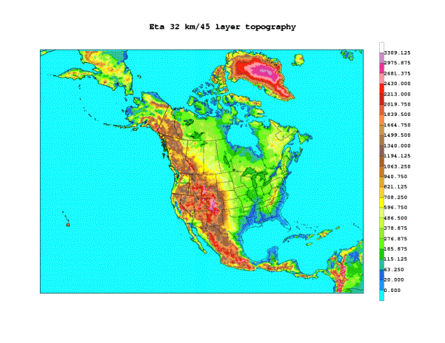
Fig. 1.
The NCEP Regional Reanalysis domain and its 32 km/45 layer topography.
3.
Preliminary results
Analyzing a variety of pilot runs
that we have performed prior to the current tentative production (e.g.,
Mesinger et al. 2002a), we have paid attention not only to their realism and
sensitivities to RR system changes, but also to their comparison against the
results of the NCEP/NCAR Global Reanalysis.
Given that the Global Reanalysis data are already available (Kalnay et
al. 1996, Kistler et al. 2001), an obvious goal of the RR, in addition to
higher resolution, should be to provide a more realistic and accurate data
set. Thus, results of various pilots
were examined in comparison with the GR data (Mesinger et al. 2002a), testing
whether there was increased agreement with observations. We shall do the same now when presenting and
commenting upon the results of available production runs. We will show precipitation results, rms fits
of analyzed as well as first guess temperature and winds to rawinsonde
observations as functions of pressure, and rms fits of 2 m temperatures to
surface observations, once again for analyses as well as for the first guess
fields.
In Mesinger et
al. (2002a) we displayed monthly precipitation totals of our 80 km pilot runs
for January and July 1998, “observed” (as available at the time), those of the
GR, and those of the RR pilot with precipitation assimilation. The observed precipitation was shown
remapped to an 80-km grid, to be a more appropriate verification of the success
of the assimilation than the original 1/8 degree input precipitation analysis,
since the analysis remapped to the Eta 80-km "native" grid was the
data assimilated into the RR pilots.
Note however that the two 80-km grids were different, the difference
being forced by the plotting package we use.
We are displaying the same three plots here in Fig 2a
("observed") and 2b (GR, and RR), except for the 32 km preliminary
production run for July 1987. The
"observed" precipitation is now remapped to a 32-km grid.
Although the
GR captures some of the characteristics of the large scale precipitation for
July 1987, it fails to depict regional features, in particular over the ConUS
area. It shows, for example, increased
precipitation over the southeastern United States, as opposed to the
Midwest. The RR, on the other hand, reproduces
extremely accurately regional features over the ConUS area, even those of a
very small scale; with few exceptions.
Agreement is quite good over the oceans also, but not to the same
extent.
Unfortunately,
following July 1987 production run precipitation assimilation was inadvertently
switched off in our system, and we have only relatively recently become aware
of it. Thus, at this time, this period
is being rerun, and we do not have the January and July 1988 32 km results that
we otherwise would have. For these and
other more recent results, please see http://wwwt.emc.ncep.noaa.gov/mmb/rreanl
where an updated version of this paper will be found. In the meantime, we recall results of the 80 km pilot shown in
Mesinger et al. (2002a). In January
1998, a generally realistic result was produced by the GR as far as the larger
scale features were concerned, with some exceptions. An even more realistic result was obtained with the RR; but not
quite as realistic as the one for July 1998, and the 32 km one shown here for
July 1987.
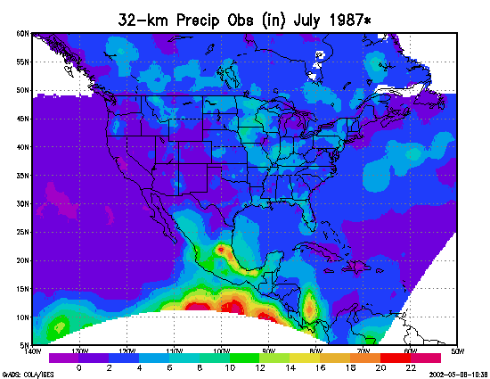
Fig 2a.
“Observed” (see text) precipitation total for July 1987 (inches).
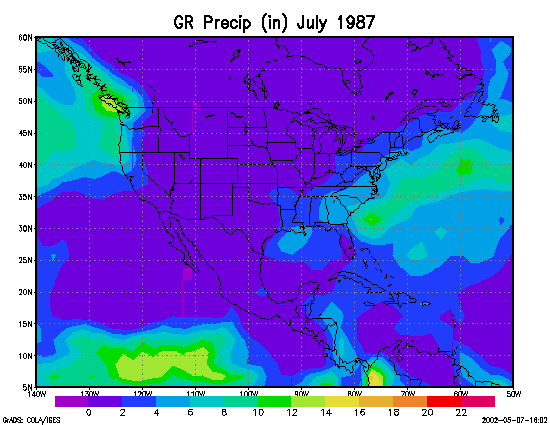
Fig 2b. GR
(upper panel) and RR (lower panel) precipitation totals for July 1987 (inches).
It should be
stressed that the RR precipitation is model produced; it is the latent heat,
derived from observations, that is assimilated (e.g., Lin et al. 1999). A better agreement of the RR in summer, when
precipitation forecasts are more difficult, thus may be found surprising. It likely indicates that our RR assimilation
method works better with the convective precipitation, dominant in summer, than
it does with the large-scale precipitation.
In Mesinger et
al. (2002a) we have shown 80 km pilot temperature and vector wind RR rms fits
to raobs, for January and July 1998, as functions of pressure. RR had shown a considerably better fit to
raobs than the GR, in particular for winds.
A puzzling feature was no improvement over the GR at the surface (1000
mb). This was later identified to have
been due to an error in the NCEP Forecast Verification System (FVS): it was
assuming the observed temperatures to be virtual temperatures and thus was
including an erroneous conversion. When
this was corrected the RR improvement over the GR at the surface was similar to
that at the other levels.
We now present in Fig. 3 a similar
set of four plots but for 1988 and the 32 km run. The advantage of the RR over that of the GR is seen to be
considerable, in particular for winds.
As in the pilot results, the advantage in winds over the GR is greatest
in the upper troposphere, and in particular in winter, January. This is a feature which we believe would
generally not have been expected. It is
however consistent with results of the operational Eta that have been reviewed
by Mesinger et al. (2002b).
As to the comparison with the
corresponding plots of the 80 km pilot for 1998, the advantage of the RR over
the GR is similar, or slightly better.
In this respect, two points might be mentioned. First, it is probably generally accepted
that the impact of resolution when comparing rms fits to data is not
necessarily beneficial, as more detail even if mostly correct may not reduce
the rms difference because of the negative impact of placement errors. Second, the 1988 results we have at the time
of this writing and are showing in Fig. 3 are obtained with no precipitation
assimilation. Improved results are
expected when these months are rerun with the precipitation assimilation
included.
Since
observations are used in the analysis, the fit of the analysis to the
observations shown in Fig. 3 is influenced both by the choice of background and
observation error covariances, and by the degree of balance imposed on the
analysis. The fit will be worse the
stronger the balance constraint imposed in the analysis scheme. For this reason, the fit of the first guess
to the observations is generally considered a better independent validation of
the quality of the analysis system. For
example, the changes implemented in the operational Eta 3D-Var in May 2001 (web
site given in section 2) resulted in improved RR fits to rawinsondes in the
first guess (3-h forecasts) but made them somewhat worse in the analysis. We therefore compare the RR and GR first
guess fits to data, similar to the rms differences shown in Fig. 3 but prior to
entering the 3D-Var analysis. From a
practical point of view, most users of the RR will want to use the analyses
(which are the best estimates) for the variables analyzed, but will use the first
guess for non-analyzed fields such as surface fluxes.
The RR fits to raobs are still
considerably better than those of the GR for the first guess fields, even
though the improvement is not as large as for the analysis fields. In comparing these plots to those of Fig. 3,
a point may come to mind additional to that of the balance imposed in the
3D-Var scheme. It is the difference in
time intervals of using the 3D-Var analyses in the two assimilation systems:
the GR is using 6 h assimilation intervals, as opposed to the 3 h intervals of
the EDAS and the RR. This results in a
considerable fraction of the data being used at more correct times, and also
makes the first guess closer to the initialization time so that there is less
time for the model error grows to take place, both favoring the RR. However, being closer to the initialization
time also allows less time for the gravity waves created by
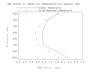
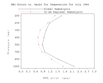
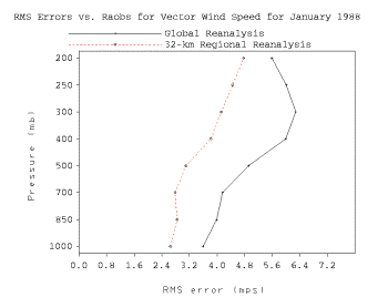
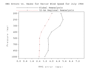
Fig. 3. RR rms fits to raobs as a function of
pressure, dashed lines, for temperature (upper panels), and for vector wind
(lower panels), for January (left panels) and July 1988 (right panels). Same, but for the GR, solid lines.
the initial imbalance to settle down, putting the
RR first guess at a disadvantage in terms of fitting the observations.
We now compare
in Figs. 5 and 6 the bias and the rms fits to surface observations of the first
guess 2 m temperature, again for January and July 1988 for both the RR (dashed
lines) and the GR (solid lines), as a function of time. Recall that, just as in Figs. 3 and 4, these
results are also obtained without precipitation assimilation, so that somewhat
improved RR fits to observations are hoped for once these months are
rerun. Stations inside the so-called
grid 212 are chosen for the verifications shown, encompassing most of Mexico to
the south and up to a considerable fraction of Canada to the north, resulting
in about 450 stations. A large majority
of these stations however are within
the ConUS area.
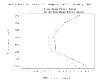
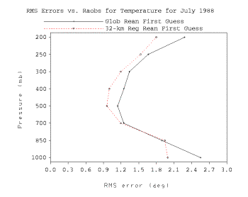
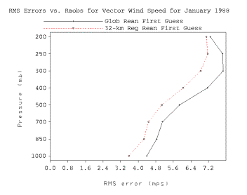
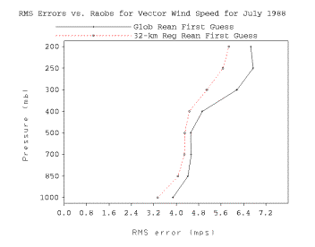
Fig. 4. RR first guess rms fits to raobs as a
function of pressure, dashed lines, for temperature (upper panels), and for
vector wind (lower panels), for January (left panels) and July 1988 (right
panels). Same, but for the GR, solid
lines.
We first show bias plots given that
the bias is perhaps of particular interest when it comes to surface
observations. In January, the RR has a
very small overall bias, as opposed to a negative bias of the GR. In July, the RR displays a negative bias,
but smaller and with much less of a diurnal oscillation than the GR which has a
strong positive bias at 0000 UTC.
The rms plots (Fig. 6) show that in
both winter and summer the RR rms fits are consistently less than those of the
GR. However, in the winter there are
occasional “unpredictable” periods that affect both the RR and the GR short-range forecasts. In the summer the diurnal cycle in the rms errors shows strong
maxima at 0000 UTC, especially for the GR, and there is less of a relationship
between exceptionally large errors in the two systems than in the winter. It is worth noting that the 1200 UTC July RR
rms differences
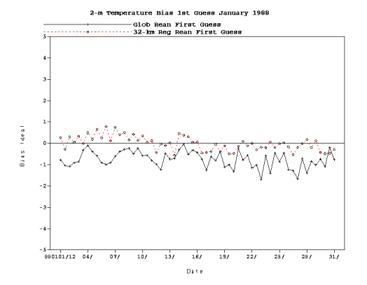
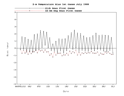
Fig 5. Bias of the first guess 2 m temperatures of the RR (dashed lines)
and the GR (solid lines), for January (upper panel) and July 1988 (lower
panel), as functions of time.
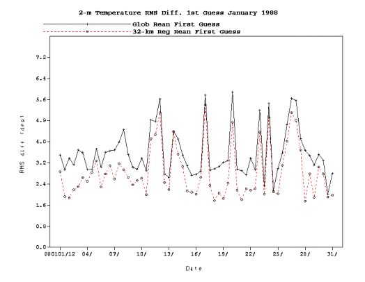
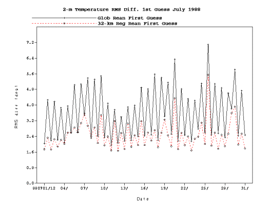
Fig 6. RMS fits to observations of the first guess 2 m temperatures of
the RR (dashed lines) and the GR (solid lines), for January (upper panel) and
July 1988 (lower panel), as functions of time.
are also consistently smaller than the their GR
counterparts, even though their negative biases tend to be greater than those
of the GR.
The bias and the rms plots of the
first guess 10 m vector wind biases and rms fits (not shown) indicate that both
the RR and the GR have a systematic negative bias, but the RR bias, on the
order of up to about 1 m/s, is less than that of the GR, which tended to be
about 1-2 m/s. However, this bias
advantage of the RR did not result in a clear
rms advantage. The rms values of the RR
and of the GR in fact were remarkably similar.
A tentative explanation for this puzzling result
is that the gravity wave noise in the RR, at its 3 h first guess time,
may be more intense that that of the 6 h noise of the GR.
4.
Work in progress and plans
NCEP management has recently
announced that half of the current NCEP mainframe computer IBM SP system will
be devoted to the production of the RR, starting in early 2003. This will obviously increase manifold the
production speed. In the meantime, we
are proceeding with our tentative production, and at the same time working
intensely on the preparation of various data sets ahead of time, so as to be
ready for the accelerated production.
The production will be carried out in two streams, one being the present
stream that has started in July 1987 to be continued into the future in real
time as in CDAS, and the other to start in 1978, eventually to overlap with the
former one. A monitoring system to
quality control the RR products and keep up with the production speed that we
expect is under development.
Results are now being posted for
evaluation by the expected user community as they become available, at http://wwwt.emc.ncep.noaa.gov/mmb/rreanl. Comments on the results posted are most
welcome and are hereby solicited.
References
Fiorino, M., 2002: Analyses and
forecasts of tropical cyclones in the ECMWF 40-year Reanalysis (ERA-40). 25th Conf. on Hurricanes and Tropical
Meteorology. San Diego, CA, Amer. Meteor. Soc., 261-265.
Kalnay, E., and Coauthors, 1996: The
NCEP/NCAR 40-Year Reanalysis Project. Bull.
Amer. Meteor. Soc., 77, 437-471.
Kanamitsu, M., and Coauthors, 2002:
NCEP/DOE AMIP-II Reanalysis (R-2). Bull.
Amer. Meteor. Soc., 83, (in
press).
Kistler, R., and Coauthors, 2001: The
NCEP-NCAR 50-Year Reanalysis: Monthly means CD-ROM and documentation. Bull. Amer. Meteor. Soc., 82, 247-267.
Lin, Y., K. E. Mitchell, E. Rogers, M.
E. Baldwin, and G. J. DiMego, 1999: Test assimilations of the real-time,
multi-sensor hourly precipitation analysis into the NCEP Eta model. 8th Conf. on Mesoscale Meteorology,
Boulder, CO, Amer. Meteor. Soc., 341-344.
Mesinger, F., G. DiMego, E. Kalnay, P.
Shafran, E. Berbery, W. Collins, W. Ebisuzaki, W. Higgins, J. Huang, Y. Lin, K.
Mitchell, D. Parrish, E. Rogers, and coauthors, 2002a: NCEP Regional Reanalysis.
Symp. on Observations, Data Assimilation,
and Probabilistic Prediction, Orlando, FL, Amer. Meteor. Soc., J59-J63.
Mesinger, F., T. Black, K. Brill,
H.-Y. Chuang, G. DiMego, and E. Rogers, 2002b: A decade + of the Eta
performance, including that beyond two days: Any lessons for the road ahead? 19th Conf. on Weather Analysis and
Forecasting/15th Conf. on Numerical Weather Prediction, San Antonio, TX,
387-390.
Zhao, Q., T. L. Black, and M. E.
Baldwin, 1997: Implementation of the
cloud prediction scheme in the Eta Model at NCEP. Wea. Forecasting, 12, 697-712.