PROBABILISTIC QUANTITATIVE PRECIPITATION FORECASTS
BASED ON THE NCEP GLOBAL ENSEMBLE
PROBABILISTIC QUANTITATIVE PRECIPITATION FORECASTS
Yuejian Zhu1, Zoltan Toth1, Eugenia Kalnay, and M. Steven Tracton
Environmental Modeling Center, NCEP, NWS/NOAA
Washington DC 20233
1. INTRODUCTION
Due to the chaotic nature of the atmosphere, the quality of weather forecasts generally degrades with increasing lead time. The rate at which predictability is lost at different locations and at different times, however, varies and depends on the instability characteristics of the prevailing atmospheric flow. Knowledge about the day to day changes in the reliability of weather forecasts may be crucial for a wide range of users. A practical approach to quantifying predictability in a nonlinear forecast situation is to run an ensemble of forecasts from slightly perturbed initial conditions. At NCEP, the breeding method is used to generate initial perturbations that are likely fast growing analysis errors. Including the control forecasts, a 17-member global ensemble is run operationally every day that provides forecast guidance out to 15 days ahead (Toth and Kalnay, 1997). Note that during the first 2-3 days, the forecast information can be enhanced by running a higher resolution experimental regional ensemble, embedded into the global ensemble forecasts, while beyond 15 days, the Climate Prediction Center of NCEP issues probabilistic guidance for temperature and precipitation.
2. ENSEMBLE GENERATED PQPF
Subjective (Toth et al., 1997) and objective evaluation of the global ensemble (Toth et al., 1998) indicates that it can provide valuable forecast information otherwise not available through the traditional use of a single control forecast only. In particular, the frequency of different weather events within the ensemble of forecasts can be interpreted in probabilistic terms. We found that the ensemble generated probabilistic circulation forecasts can be easily calibrated, resulting in practically perfectly calibrated forecasts (i. e., forecast probabilities matching observed frequencies over the long run).
In this study, through a series of examples, we present a subjective evaluation of probabilistic quantitative precipitation forecasts (PQPFs) generated from the global ensemble over the US. The probabilistic forecasts are created by counting how many of the ensemble members exceed any given 24-hour accumulated precipitation amount, and then dividing that number by the total number (17) of ensemble forecasts. For example, when precipitation amount exceeds 1 inch in 11 out of a total of 17 members, the forecast probability for the 1 inch limit is 0.65 (11/17). 1-15 days lead time PQPFs, based on the NCEP global ensemble, can be found on the web at: http://sgi62.wwb.noaa.gov:8080/ens/enshome.html.
3. POTENTIAL PREDICTABILITY
Our first example is concerned with potential predictability.We assume that our numerical weather prediction
(NWP) model is perfect and that errors are due only to the
fact that the initial condition of the atmosphere is not known
exactly. We use the operational ensemble to represent the
uncertainty in the initial condition: for each member, except
the controls, a small perturbation has been added to the
control analysis of the state of the atmosphere at initial
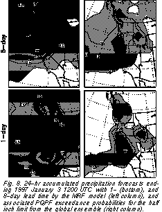
time. Fig. 1 shows a series of control forecasts of 24-hour
accumulated precipitation amount, with increasing lead
time, for a precipitation event associated with the tail of a
well predictable large scale cold front that passed over the
Florida Penninsula.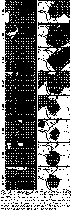 Comparing the 1-day lead time forecast, which is generally quite accurate and can be considered as a proxy for verification, to the longer lead time forecasts, we can see a rather familiar pattern: none of the
forecasts (except at 5-day lead), gave the right location for
the maximum amount of precipitation. The sucessive forecasts are different not because of model deficiencies
(since all forecasts are made with the same model) but
rather due to minor differences in their initial conditions.
Comparing the 1-day lead time forecast, which is generally quite accurate and can be considered as a proxy for verification, to the longer lead time forecasts, we can see a rather familiar pattern: none of the
forecasts (except at 5-day lead), gave the right location for
the maximum amount of precipitation. The sucessive forecasts are different not because of model deficiencies
(since all forecasts are made with the same model) but
rather due to minor differences in their initial conditions.
On the other hand, if we look at the PQPFs that are based on 17 ensemble forecasts that filter out the initial value uncertainties, we see a very clear signal: all 8 forecasts with different lead times give the maximum value of probability at the location where the precipitation had its maximum in the 1-day lead control forecast. This remarkable agreement, in contrast with the scatter of the location of maximum values in the control forecasts, highlights the potential advantage of running an ensemble of forecasts, instead of a single higher resolution control. The ensemble, in terms of PQPFs, can better identify the most likely location and amount of precipitation events, whereas the control just picks one of the possible scenarios (which can often be quite different from the most likely one). We emphasize that the ensemble consists of mainly low resolution (T62) forecasts and therefore requires approximately the same computer resources as running the high resolution (T126) control.
4 . A TYPICAL EXAMPLE
Following the highly predictable case above, here we present a more typical example of ensemble-based PQPF. The precipitation event is again related to a well predictable cold front, now streching across the eastern half of the continental US. The observed precipitation (estimated based on raingage and radar measurements, Baldwin and Mitchell, 1996) is shown in Fig. 2. At short (1-day) lead time the high resolution global control forecast could capture well the large scale precipitation event (Fig. 3). However, the regional scale details (for example, heavy precipitation off the Louisiana coast and southwest of Florida) are not captured at the T126 resolution.
The lower resolution ensemble (Fig. 3) provides very similar information to the control forecast at day 1. However, at longer (5-, and especially at 7-day) lead times the advantage of the ensemble approach becomes evident. The control forecast at 5-day lead time is very similar to the 1-day forecast and consequently verifies very well on the large scales. Such a good performance for the MRF forecast is not typical and a forecaster would not necessarily have strong confidence in a 5-day precipitation forecast. In this case, however, the ensemble PQPFs did not change much from 1-day to 5-day lead time either. All ensemble members still agree fairly well with the control, suggesting an unusually high confidence in the 5-day forecast.
At day 7 the control forecast for the southern part of the precipitation pattern is still rather skilful. However, the northern half of the heavy precipitation forecast area is substantially displaced to the northeast, as compared to the verification. In contrast, the axis of highest probabilities from the ensemble is virtually unchanged, providing an excellent warning for heavy precipitation. Note also that the area of probabilities at day 7 (say, the 20% contour) is much enlarged from day 5, suggesting more uncertainty in the forecasts, in line with the poorer perfomance of the control forecast.
5. THE WINTER OF 1996/97 FLOOD IN CALIFORNIA
Series of heavy precipitation events along the west coast caused serious floods in different parts of California during the winter of 1996/97. Most of these precipitation events were predicted well by the NCEP global forecast system. Here we will focus on one event in late December - early January to highlight the advantages of using an ensemble as compared to relying on a single forecast only.
Fig. 4 shows the temporal evolution of observed precipitation in a northern California mesoscale size area between 24 December and 3 January, along with the 1-, 3-,
and 5-day MRF control forecasts. The 1- and 3-day control forecasts verify very well whereas the 5-day forecasts
missed much of the heavy precipitation that was observed
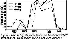
between 30 December and 2 January. In contrast, the ensemble-based probabilities for precipitation above 1 inch
(Fig. 5) are high throughout the whole event even at day 5.
Equally important, the ensemble predicted very well
around which date the heavy precipitation would start and
end: notice that the probabilities are high only for 4-5 days
over the period of largest accumulated observed precipitation, sharply rising before, and dropping after the event.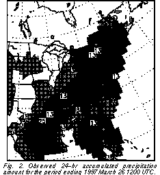
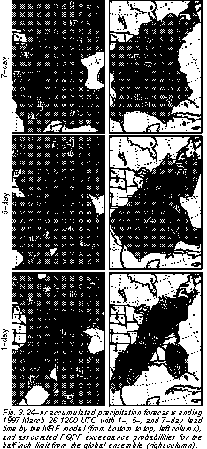
Fig. 6 offers another way of comparing the behavior of the control and ensemble forecasts during this precipitation event. Shown are the control accumulated precipitation amount forecasts, along with the ensemble-based PQPFs with different lead times, all forecasts valid on 2 January for a small region of maximum observed precipitation. Again we can see that the ensemble gives consistently high probabilities for precipitation amounts exceeding 1 inch up to 6 days in advance, whereas the control forecast predicts large amounts consistently only from 3 days lead time.
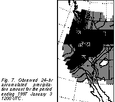
The ensemble is not only able to extend the predictability of precipitation events in time but often also offers a more meaningful indication for the possible spatial distribution of precipitation. Fig. 7 shows the observed precipitaion on 3 January.The control and ensemble forecasts at 1-day lead time (Fig. 8) capture well the main features of the precipitation pattern that day: heaviest precipitation along the (1) central California-Nevada border, with more than 10 mm rain extending to the area of (2) the Great Salt Lake, and another area of heavy precipitation in (3) western Washington state.
It is remarkable how similar the 8-day lead time ensemble-based PQPF is to the 1-day chart (and consequently to observations): The three main centers of precipitation activity still have 65%, 47%, and 40% probability of half inch or more rain associated with them. Note that the observed pattern is really only one realization among many others possible so it is not expected to match exactly the highest forecast probabilities. While the ensemble PQPF highlights the most likely distribution of heavy rain given the initial state and its uncertainty, the high resolution control forecast examplifies only one of the possible scenarios. Not surprisingly, it has much less correspondence with the observed precipitation distribution (Fig. 7) than does the ensemble-based PQPF chart.
6. SUMMARY AND DISCUSSION
Through a number of examples we compared subjectively the performance of precipitation amount forecasts from a high resolution (T126) control prediction to that of PQPFs based on a lower (T62) resolution ensemble. It is important to note that the generation of the lower resolution ensemble requires approximately the same computer resources as running the higher resolution control. The results, supported by the evaluation of many other cases, indicate that the ensemble can extend the predictability of precipitation events by a day or two as compared to using only a high resolution control forecast. The improvement the ensemble offers is manifested in forecasts that (1) have useful information for longer lead times, (2) behave much more consistently in time, (3) have more accurate information about the spatial distribution of heavy rainfall, and (4) are associated with a flow dependent estimate of reliability.
We should point out that the present study has several
limitations. In the future, we plan to fit a 3-parameter Gamma distribution (Lehman, 1997) to derive more accurate
probability distributions based on the ensemble forecasts.
The forecast probability distributions will then be
compared to observed precipitation distributions from the
past season. This will enable us to "calibrate" the PQPFs,
thus making them more reliable (i. e., make the forecast
probabilities match the observed frequencies of different
precipitation events over the long run).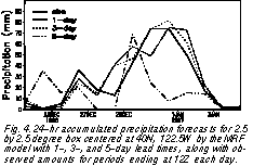
Notwithstanding the advantages of the ensemble
PQPFs demonstrated in this study, we note that the success of the ensemble approach hinges upon the quality of
the NWP model forecasts. During the summer months, for
example, when model performance is generally poorer,
the ensemble has less to offer. This highlights the need for
further model improvements. The improvements, however, should not be sought solely through increased model
resolution, and especially not at the expense of running an
ensemble: as we saw, using the same computer resources
for running an ensemble, instead of a double resolution
control, offers much more benefit to the users. This conclusion is true not only for heavy precipitation guidance but
also for circulation forecasts in general (Toth et al., 1998).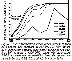
8. REFERENCES
Lehman, R. L., 1997: Modeling precipitation data with Pearson Type lll distributions: Overview of new interactive software "PFIT". Preprints of the 13th Conference on Hydrology, 2-7 February 1997, Long Beach, California, p. J150-J153.
Baldwin, M.E., and K. E. Mitchell: The NCEP hourly multi-sensor U.S. precipitation analysis. Preprints, 11th NWP Conf Norfolk, VA, 19-23 Aug. 1996, J95-96.
Toth, Z., and E. Kalnay, 1997: Ensemble forecasting at NCEP and the breeding method. Mon. Wea. Rev, 225, in print.
Toth, Z., E. Kalnay, S. Tracton, R. Wobus, and J. lrwin, l997: A synoptic evaluation of the NCEP ensemble. Weather and Forecasting, 12, 140-153.
Toth, Z., Y. Zhu, T. Marchok, . Tracton, and E. Kalnay, 1998:
Verification of the ncep global ensemble forecasts. Preprints of the 12th Conference on Numerical Weather Prediction, 11-16 January 1998, Phoenix, Arizona, in print.