 THE 1999 WINTER STORM RECONNAISSANCE PROGRAMTHE 1999 WINTER STORM RECONNAISSANCE PROGRAM
Zoltan Toth1, Istvan Szunyogh2,
Sharan Majumdar3, Rebecca Morss4, Brian Etherton3, Craig Bishop3, and Stephen Lord
Environmental Modeling Center, NCEP, NWS/NOAA
Washington DC 20233
1. INTRODUCTION
Between January 13 and February 10, 1999 a quasi-operational field program took place over the northeastern
Pacific. The aim of the program was to improve 1-4 days
lead time weather forecasts of critical weather events by
adaptively collecting data in otherwise poorly observed
oceanic areas.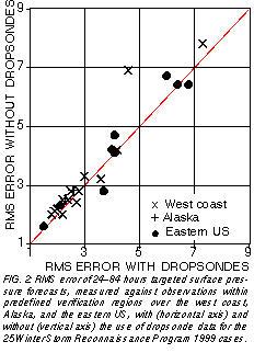
The critical weather events for which the forecasts
were to be improved were selected by forecasters at the
Hydrometeorological Prediction Center of NCEP, based
on input from NWS field forecast offices. The areas from
where adaptively taken extra observations were expected
to have the maximum forecast impact were selected by the
Environmental Modeling Center of NCEP, using the Ensemble Transform (ET, Bishop and Toth, 1999) method.
In a total of 15 cases one or two aircraft (the NOAA
G-lV and/or USAF Reserve C130 planes) were deployed
in these "sensitive" regions to collect data by releasing a
total of close to 500 dropsondes. The Winter Storm Reconnaissance 1999 (WSR99) program coincided with a research experiment aimed at studying clear air turbulance
(SCATCAT, M. Shapiro and C. Girz, personal communication).
The flight missions were often designed to improve
weather forecasts for more than one verification region, at
different lead times. In 14 cases the West coast, in 9 cases
the eastern US, while in 2 cases Alaska weather forecasts
were supported by the flight missions.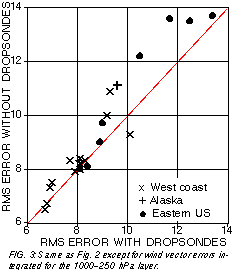
2. DATA IMPACT
The average sensitivity pattern for the 15 flight cases
is displayed in Fig. 1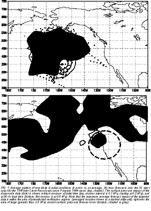 . The flights, originating from Hawaii
and Anchorage, Alaska, could reasonably sample the sensitive area in most cases. All dropsonde data were used
operationally. To evaluate the impact of the targeted data,
a parallel (control) data assimilation and forecast cycle,
from which all dropsonde data were excluded, was run and
tested against the operational analysis/forecast results
throughout the field program. Fig. 1 shows what impact the
assimilation of extra dropsonde data at T62 model resolution made in addition to using all other operationally available data. In the most sensitive and best observed areas
the average initial impact in surface pressure exceeds 0.6
hPa.
. The flights, originating from Hawaii
and Anchorage, Alaska, could reasonably sample the sensitive area in most cases. All dropsonde data were used
operationally. To evaluate the impact of the targeted data,
a parallel (control) data assimilation and forecast cycle,
from which all dropsonde data were excluded, was run and
tested against the operational analysis/forecast results
throughout the field program. Fig. 1 shows what impact the
assimilation of extra dropsonde data at T62 model resolution made in addition to using all other operationally available data. In the most sensitive and best observed areas
the average initial impact in surface pressure exceeds 0.6
hPa.
The average location of the verification region for the
14 west coast cases is shown as an ellipsoid on the bottom
panel of Fig. 1. The average verification lead time for these
cases is 36 hours. The same panel also indicates where
the average 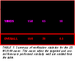
 control 36-hour forecast error is large. Note
the local maximum in surface pressure forecast error within the verification area, cofirming that the weather events
selected by the forecasters were associated with a large
degree of uncertainty. The maximum impact of the extra
data at 36 hours lead time (difference between forecasts
initialized with and without the dropsonde data), as seen
from the same figure, reaches the verification region, and
has its largest values (1.1 hPa) over the area of largest
forecast errors. Note that the average impact of the data
has a magnitude that is roughly one third of the forecast error itself.
control 36-hour forecast error is large. Note
the local maximum in surface pressure forecast error within the verification area, cofirming that the weather events
selected by the forecasters were associated with a large
degree of uncertainty. The maximum impact of the extra
data at 36 hours lead time (difference between forecasts
initialized with and without the dropsonde data), as seen
from the same figure, reaches the verification region, and
has its largest values (1.1 hPa) over the area of largest
forecast errors. Note that the average impact of the data
has a magnitude that is roughly one third of the forecast error itself.
3. VERIFICATION OF TARGETED FORECASTS
In the previous section we saw that the targeted dropsonde data had a substantial impact on the targeted forecasts. Here we will explore whether this impact is positive,
i. e., whether the error in the targeted forecasts is reduced
compared with the control forecasts.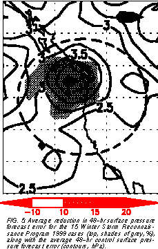
The operational, targeted forecasts and the control
forecasts are verified objectively using surface pressure
(Fig.2) and wind (Fig. 3) observations at verification time
and within the 1000 km radius verification regions. The
24-hour accumulated precipitation forecasts were evaluated subjectively by considering the amount and timing
of precipitation events. Combining the three different verification statistics, the overall results indicate that in close to
80% of the verification cases, the targeted data improved
the quality of the critical weather forecasts (Table 1). In particular, 18 out of the 23 cases that can be evaluated the
forecast error was reduced. This result is statistically significant at the 0.5% level.
4. A CASE STUDY
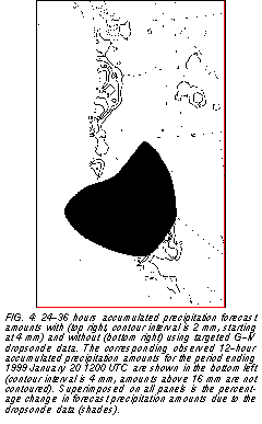
In Fig. 4 shown are the control and operational targeted 24-36 hours lead time accumulated precipitation forecasts and the corresponding raingage-based analyzed amounts for the 12-hour period ending at 1200 UTC January 20, 1999. The shaded area indicates the impact of the data, which was to shift the area of maximum precipitation by increasing the predicted amounts around the area of maximum observed precipitation in central California. Note that both forecasts were run at T62 (approximately 220 km resolution) and therefore were unable to capture the orographically forced local maxima in the observed precipitation amount.
5. HISTORICAL PERSPECTIVE
In Fig. 5 we show the percentage of the control
48-hour surface pressure forecast error that was removed
by the use of dropsonde data collected during the 15 flight
missions. The maximum error reduction is in the 10-20%
range and is well within the average location of the verification regions at 48-hour lead time. Also, the area of maximum error reduction coincides with the location of maximum control forecast error, attesting to the success of the
targeting procedure.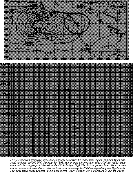
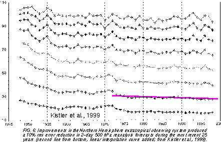
A question can be asked regarding the significance of
the 10-20% error reduction. To address this quesiton we
use a figure from Kistler et al. (1999, Fig. 6). Reanalyses
and reforecasts were created, using the same NCEP analysis/forecast system, for the past few decades. In this setup, the forecasts can improve with time only due to imporvements in data quantity and/or quality. As we can see
from the figure, it took approximately 25 years of efforts
through the introduction of new observing platforms etc. to
reduce the 2-day 500 hPa height errors over the Northern
Hemisphere extratropics by 10%. During the Winter Storm
Reconnaissance program, the same level of error reduction was achieved over the selected critical verification regions by disposing on the order of 30 dropsondes on every
other day.
6. CONCLUSIONS
Based on the positive targeting experience accumulated during the FASTEX (Szunyogh et al., 1999a), NORPEX (Szunyogh et al, 1999b), CALJET (Ralph et al., 1999)
and WSR99 (Szunyogh et al., 1999c) field programs,
NCEP plans to fully operationalize the Winter Storm Reconnaissance program, using the NOAA G-lV and USAF
C130 planes.
In preparation for a full operational implementation, for
some WSR99 missions special sensitivity calculations
were also prepared, in addition to the traditional sensitivity
charts (Fig. 7, top panel). These special calculations provide an estimate of expected data impact resulting from using a number of preselected flight patterns (Fig. 7, bottom
panel). In the example shown the largest forecast impact
is expected from flight number 23, which covers the central
area of sensitivity as displayed on the traditional senistivity
chart in the upper panel of Fig. 7. The use of predesigned
flight tracks and associated track specific sensitivity calculations will facilitate the transition process of the targeting technology inbto NWS operations.
7. ACKNOWLEDGEMENTS
The 1999 Winter Storm Reconnaissance Program would not have been possible without the work of a large number of participants and collaborators. We would like to acknowledge the dedicated work of the NOAA G-lV (led by Sean White) and the USAF Reserve C-130 flight crews (coordinated by Jon Talbot). Coordination with the flight facilities was provided by CARCAH, led by John Pavone. The WSR program benefitted from a collaboration with the concurrently run SCATCAT (Severe Clear-Air Turbulence Colliding with Air Traffic) research program under the leadership of Cecile Girz (NOAA/ERL/FSL) and Mel Shapiro (NCAR). The European Centre for Medium-Range Weather Forecasts is credited for providing their ensemble forecast data to be used in the sensitivity calculations in real time. The forecast cases were selected in real time by NWS field offices and NCEP/HPC forecasters coordinated by David Reynolds. Mark Iredell, Jack Woollen, and Timothy Marchok provided valuable help with setting up the parallel analysis/forecast cycle, manipulating data, and creating graphics.
8. REFERENCES
Bishop, C. H., Z. Toth, 1999: Ensemble Transformation and Adaptive Observations. J.Atmos. Sci. 56, 1748-1765.
Kistler
Ralph, F. M., O. Persson, D. Reynolds, W. Nuss, D. Miller, J. Schmidt, D. Jorgensen, J. Wilczak, P. Neiman, J.-W. Bao, D. Kingsmill, Z. Toth, C. Velden, A. White, C. King, and J. Wurman, 1999: The California Land falling Jets experiment (CALJET): Objectives and design of a coastal atmosphere-ocean observing system deployed during a strong El Nińo. 3rd Symp. Integrated Observing Systems, 10-15 Jan. 1999, Dallas, TX, AMS 78-81.
Szunyogh, I., Z. Toth, K. A. Emanuel, C. Bishop, C. Snyder, R. Morss, J. Woolen, and T. Marchok, 1999a: Ensemble-based targeting experiments during FASTEX: The impact of dropsonde data from the LEAR jet. QJRMS, in print.
Szunyogh, I., Z. Toth, S. Majumdar, R. Morss, C. Bishop, and S. Lord, 1999b: Ensemble-based targeted observations during NORPEX. Preprints of the 3rd Symposium on Integrated Observing Systems,10-15 January 1999, Dallas, Texas, 74-77.
Szunyogh, I., Z. Toth, S. Majumdar, R. Morss, B. Etherton, and C. Bishop, 1999c: The effect of targeted dropsonde observations during the 1999 Winter Storm Reconnaissance program. Mon. Wea. Rev., under review.