Real-Time Mesoscale Analysis/UnRestricted Mesoscale Analysis/RTMA-Rapid Update


System Overview
The Real Time Mesoscale Analysis (RTMA) and the UnRestricted Mesoscale Analysis system (URMA) are 2DVar analysis systems that provide analyses of National Digital Forecast Database parameters for CONUS, Alaska, Hawaii, Puerto Rico, and Guam. The RTMA is run hourly for all domains to provide situational awareness. The URMA is also run hourly but with a six hour time delay to capture late arriving data at NCEP. While RTMA is considered for situational awareness the URMA is considered for verification/validation. The URMA also serves as a critical component in the National Blend of Models (NBM) program, as it is used for calibration and validation. As of December 2017, a new Rapid Update version of the RTMA (RTMA-RU) was implemented. This system provides a new analysis every 15 minutes and is for users in need of fast, low-latency analysis products (e.g. the aviation community).
EMC has created a RTMA/URMA Discussion Group on VLab (a Vlab account is required to access it).
External users can also access the RTMA/URMA Discussion Group (no log-in required).
Documentation for RTMA/URMA can be found at the official COMET site.
WHERE TO FIND GRAPHICS FOR THE RTMA-URMA/RTMA-RU
Official guidance for the operational CONUS, Alaska, and Guam RTMA systems can be found at the Model Analysis and Guidance (MAG) web page. The MAG page is supported 24 hours a day and 7 days a week.
EMC maintains a web page of RTMA/URMA/RTMA-RU graphics that supplements the NCEP MAG site. EMC-generated web pages are experimental and not subject to 24/7 support, and will be unavailable during computer outages.
RTMA Description
The RTMA (De Pondeca et al 2011, Pondeca et al 2015) is an hourly updated, 2-dimensional variational analysis of surface sensible weather fields. The system operates with a horizontal grid-spacing of 2.5 km for all domains except Alaska (3 km) and Puerto Rico (1.25 km), and is disseminated to users via FTP and the AWIPS Satellite Broadcast Network (SBN) with a latency of 55 min. RTMA produces analyses for CONUS, Hawaii, Alaska, Puerto Rico, and Guam (see Figure 1). The CONUS background (first-guess) field is derived from a terrain-dependent, downscaled blend of the hourly updated 3-km operational High-Resolution Rapid Refresh (HRRR; Alexander et al. 2015) model and the 3-km inner nest of the North American Mesoscale model (NAM; Rogers et al. 2017). First-guess fields for AK are derived from downscaled and blended forecasts from the NAM AK nest and the 3-km Alaska-HRRR. Hawaii and Puerto Rico domains utilize the NAM's Hawaii and Puerto Rico downscaled 3-km nests, respectively. Finally, the RTMA uses downscaled GFS output to serve as the background for the Guam domain. Output fields include standard surface fields: 2-m temperature and dew point, 10-m wind and gust, visibility, cloud cover, ceiling, surface pressure, and precipitation.
The precipitation analysis is mapped from the 1km radar-only MRMS ConUS QPE.
The very first version of RTMA was implemented on August 22nd, 2006. A comprehensive list of all RTMA/URMA implementations can be found at the EMC Mesoscale Systems Reference Page.
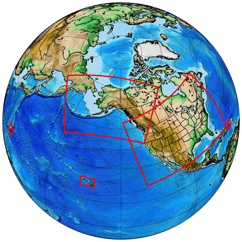
Figure 1 : Domains for which the RTMA analysis is run in NCEP Production.
URMA Description
A second application of the same RTMA/GSI software is the Un-Restricted Mesoscale Analysis (URMA; Pondeca et al. 2015), which uses additional, late-arriving observations that did not make the RTMA data-cutoff in real time. URMA is executed by running the same RTMA system, but 6 hours later in time, to pick up the late-arriving observations. URMA includes all analysis variables found in RTMA as well as max/min 2-m temperature, max/min 2-m relative humidity, and significant wave height. URMA is the "Analysis of Record" for the NWS (including the National Blend of Models), against which operational forecasts will be verified. URMA produces analyses for CONUS, Hawaii, Alaska, and Puerto Rico (see Figure 2).
The first version of URMA was implemented December 18th, 2013. The precipitation analysis is mapped from the 4.7-km NCEP Stage IV (from River Forecast Center QPEs) over ConUS/AK/PR, and gauge-corrected MRMS and CMORPH in the offshore regions of the ConUS grid.
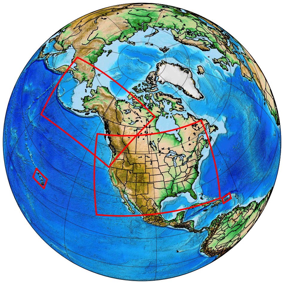
Figure 2 : Domains for which the URMA analysis is run in NCEP production.
RTMA-RU Description
The Rapid Update version of the RTMA system (RTMA-RU; Yang et al. 2017) updates at a 15 min interval with a <20 min latency for aviation customers, with special focus on Helicopter Emergency Medical Services. RTMA-RU produces an analysis every 15 minutes for CONUS (see Figure 3).
The first version of RTMA-RU was implemented December 13th, 2017.
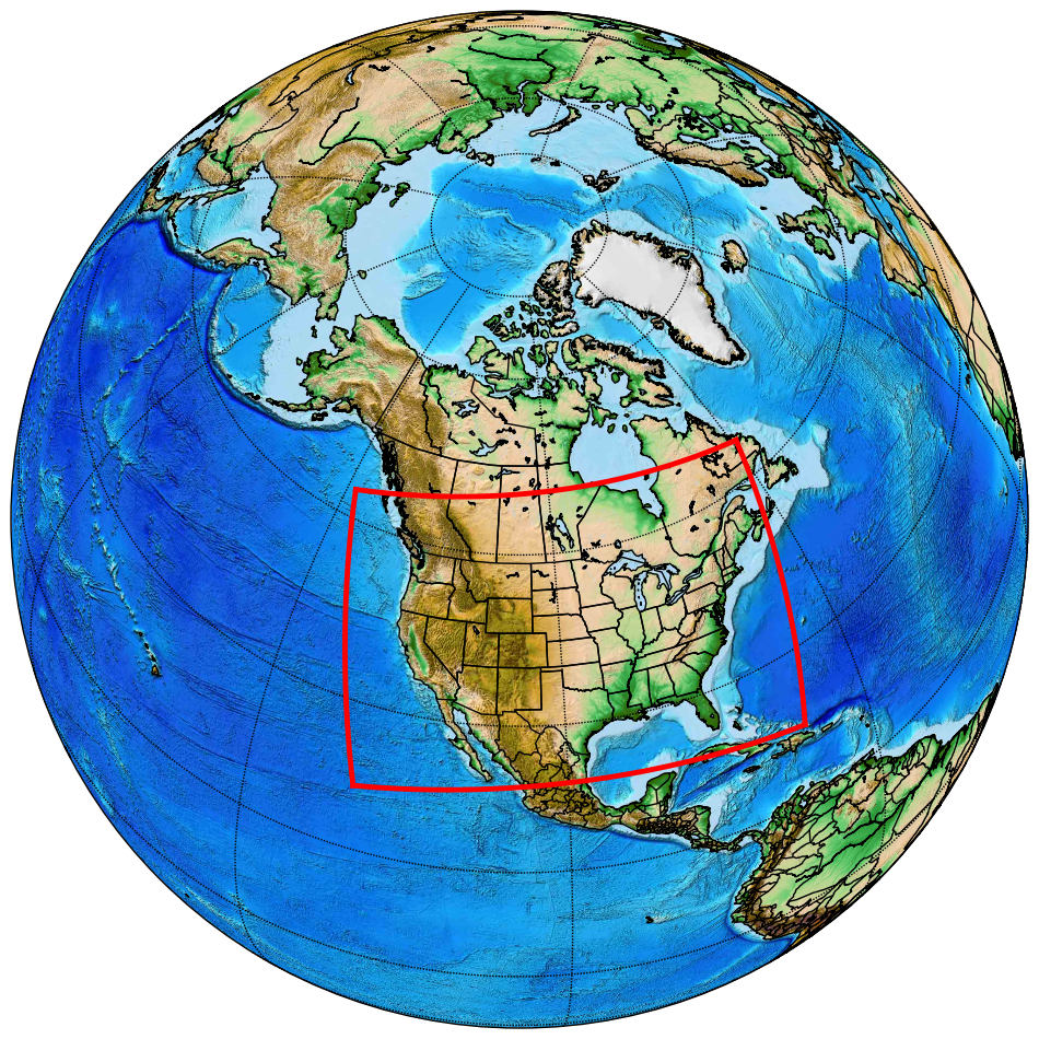
Figure 3: The CONUS domain for which the RTMA-RU system is run in NCEP Production.
RTMA/URMA/RTMA-RU v2.7/PCPANL 3.1
Implemented on 4 December 2018
Changes :
- Improve RTMA-RU product latency to 15 minutes after analysis time;
- Update background error covariance model to include flow-dependence;
- Improved observation quality control, especially for winds;
- New, unified terrain and land-sea mask for Alaska;
- Begin using mesonet visbility observations and CLARUS QC'd obs;
- Add ceiling height and sky cover analysis to OCONUS domains;
- Enhance ceiling height and visibility analysis through improved algorithm;
- Address precipitation coverage gaps near CONUS coastlines;
- Add significant wave height analysis to OCONUS domains;
- Remove legacy coarse-resolution output grids;
RTMA/URMA/RTMA-RU v2.8/PCPANL 4.0
Implemented on 28 July 2020
Changes :
- Introduction of similarity theory calculations in the forward operator for the
assimilation of near-surface winds to account for non-standard anemometer heights
associated with mesonet observations.
- Extending the significant wave height analysis to the Great Lakes and Guam.
- The sea/land mask of the background is used for the significant wave height analysis.
- Re-tuning of the sky cover analysis to: ensure consistency with the ceiling analysis, introduce quality control at night when satellite observations are of lower quality, and refine data thinning and decorrelation lengths to produce a more consistent analysis.
- The addition of a sky cover analysis to RTMA-RU.
- Increase in analysis resolution over Puerto Rico from 2.5 km to 1.25 km for consistency with NDFD.
- Introduction of enhanced background error for temperature in complex terrain for OCONUS (was implemented in CONUS in v2.7)
- Introduction of refined observation selection algorithm for OCONUS (was implemented for CONUS in v2.7)
- Removal of a 1-2-1 smoother previously applied to the derived dewpoint increments to address a moist bias in complex terrain.
- Use of radar-only MRMS QPE instead of first-run Stage II/IV for precipitation RTMA; discontinuation of various Stage II analyses.
- Stage IV analysis changing from GRIB1 to GRIB2.
- Add 6h/24h snowfall analysis from NOHRSC to the precipitation URMA system.
- Smoother offshore filling of ConUS precipitation URMA.
- New temperature downscaling is used for Guam, Hawaii and Puerto Rico in the background fields (HiresW and NAM Smartinit).
- New wind downscaling is used for CONUS and Alaska in the background fields (HRRR Smartinit)
- Land cover is used instead of vegetation type for the coastal adjustment of the background fields (RAP Smartinit)
System Overview
The Real Time Mesoscale Analysis (RTMA) and the UnRestricted Mesoscale Analysis system (URMA) are 2DVar analysis systems that provide analyses of National Digital Forecast Database parameters for CONUS, Alaska, Hawaii, Puerto Rico, and Guam. The RTMA is run hourly for all domains to provide situational awareness. The URMA is also run hourly but with a six hour time delay to capture late arriving data at NCEP. While RTMA is considered for situational awareness the URMA is considered for verification/validation. The URMA also serves as a critical component in the National Blend of Models (NBM) program, as it is used for calibration and validation. As of December 2017, a new Rapid Update version of the RTMA (RTMA-RU) was implemented. This system provides a new analysis every 15 minutes and is for users in need of fast, low-latency analysis products (e.g. the aviation community).
EMC has created a RTMA/URMA Discussion Group on VLab (a Vlab account is required to access it).
External users can also access the RTMA/URMA Discussion Group (no log-in required).
Documentation for RTMA/URMA can be found at the official COMET site.
WHERE TO FIND GRAPHICS FOR THE RTMA-URMA/RTMA-RU
Official guidance for the operational CONUS, Alaska, and Guam RTMA systems can be found at the Model Analysis and Guidance (MAG) web page. The MAG page is supported 24 hours a day and 7 days a week.
EMC maintains a web page of RTMA/URMA/RTMA-RU graphics that supplements the NCEP MAG site. EMC-generated web pages are experimental and not subject to 24/7 support, and will be unavailable during computer outages.
RTMA Description
The RTMA (De Pondeca et al 2011, Pondeca et al 2015) is an hourly updated, 2-dimensional variational analysis of surface sensible weather fields. The system operates with a horizontal grid-spacing of 2.5 km for all domains except Alaska (3 km) and Puerto Rico (1.25 km), and is disseminated to users via FTP and the AWIPS Satellite Broadcast Network (SBN) with a latency of 55 min. RTMA produces analyses for CONUS, Hawaii, Alaska, Puerto Rico, and Guam (see Figure 1). The CONUS background (first-guess) field is derived from a terrain-dependent, downscaled blend of the hourly updated 3-km operational High-Resolution Rapid Refresh (HRRR; Alexander et al. 2015) model and the 3-km inner nest of the North American Mesoscale model (NAM; Rogers et al. 2017). First-guess fields for AK are derived from downscaled and blended forecasts from the NAM AK nest and the 3-km Alaska-HRRR. Hawaii and Puerto Rico domains utilize the NAM's Hawaii and Puerto Rico downscaled 3-km nests, respectively. Finally, the RTMA uses downscaled GFS output to serve as the background for the Guam domain. Output fields include standard surface fields: 2-m temperature and dew point, 10-m wind and gust, visibility, cloud cover, ceiling, surface pressure, and precipitation.
The precipitation analysis is mapped from the 1km radar-only MRMS ConUS QPE.
The very first version of RTMA was implemented on August 22nd, 2006. A comprehensive list of all RTMA/URMA implementations can be found at the EMC Mesoscale Systems Reference Page.
Figure 1 : Domains for which the RTMA analysis is run in NCEP Production.
URMA Description
A second application of the same RTMA/GSI software is the Un-Restricted Mesoscale Analysis (URMA; Pondeca et al. 2015), which uses additional, late-arriving observations that did not make the RTMA data-cutoff in real time. URMA is executed by running the same RTMA system, but 6 hours later in time, to pick up the late-arriving observations. URMA includes all analysis variables found in RTMA as well as max/min 2-m temperature, max/min 2-m relative humidity, and significant wave height. URMA is the "Analysis of Record" for the NWS (including the National Blend of Models), against which operational forecasts will be verified. URMA produces analyses for CONUS, Hawaii, Alaska, and Puerto Rico (see Figure 2).
The first version of URMA was implemented December 18th, 2013. The precipitation analysis is mapped from the 4.7-km NCEP Stage IV (from River Forecast Center QPEs) over ConUS/AK/PR, and gauge-corrected MRMS and CMORPH in the offshore regions of the ConUS grid.
Figure 2 : Domains for which the URMA analysis is run in NCEP production.
RTMA-RU Description
The Rapid Update version of the RTMA system (RTMA-RU; Yang et al. 2017) updates at a 15 min interval with a <20 min latency for aviation customers, with special focus on Helicopter Emergency Medical Services. RTMA-RU produces an analysis every 15 minutes for CONUS (see Figure 3).
The first version of RTMA-RU was implemented December 13th, 2017.
Figure 3: The CONUS domain for which the RTMA-RU system is run in NCEP Production.
RTMA/URMA/RTMA-RU v2.7/PCPANL 3.1
Implemented on 4 December 2018
Changes :
- Improve RTMA-RU product latency to 15 minutes after analysis time;
- Update background error covariance model to include flow-dependence;
- Improved observation quality control, especially for winds;
- New, unified terrain and land-sea mask for Alaska;
- Begin using mesonet visbility observations and CLARUS QC'd obs;
- Add ceiling height and sky cover analysis to OCONUS domains;
- Enhance ceiling height and visibility analysis through improved algorithm;
- Address precipitation coverage gaps near CONUS coastlines;
- Add significant wave height analysis to OCONUS domains;
- Remove legacy coarse-resolution output grids;
RTMA/URMA/RTMA-RU v2.8/PCPANL 4.0
Implemented on 28 July 2020
Changes :
- Introduction of similarity theory calculations in the forward operator for the assimilation of near-surface winds to account for non-standard anemometer heights associated with mesonet observations.
- Extending the significant wave height analysis to the Great Lakes and Guam.
- The sea/land mask of the background is used for the significant wave height analysis.
- Re-tuning of the sky cover analysis to: ensure consistency with the ceiling analysis, introduce quality control at night when satellite observations are of lower quality, and refine data thinning and decorrelation lengths to produce a more consistent analysis.
- The addition of a sky cover analysis to RTMA-RU.
- Increase in analysis resolution over Puerto Rico from 2.5 km to 1.25 km for consistency with NDFD.
- Introduction of enhanced background error for temperature in complex terrain for OCONUS (was implemented in CONUS in v2.7)
- Introduction of refined observation selection algorithm for OCONUS (was implemented for CONUS in v2.7)
- Removal of a 1-2-1 smoother previously applied to the derived dewpoint increments to address a moist bias in complex terrain.
- Use of radar-only MRMS QPE instead of first-run Stage II/IV for precipitation RTMA; discontinuation of various Stage II analyses.
- Stage IV analysis changing from GRIB1 to GRIB2.
- Add 6h/24h snowfall analysis from NOHRSC to the precipitation URMA system.
- Smoother offshore filling of ConUS precipitation URMA.
- New temperature downscaling is used for Guam, Hawaii and Puerto Rico in the background fields (HiresW and NAM Smartinit).
- New wind downscaling is used for CONUS and Alaska in the background fields (HRRR Smartinit)
- Land cover is used instead of vegetation type for the coastal adjustment of the background fields (RAP Smartinit)