Joint Observing System Simulation Experiment (JOSSE)
Data set
at NASA/NCCS portal and NCAR
Updated in July 3, 2013
The data set described in this manuscript contains the data required to conduct initial OSSEs. The data set includes existing observations from the 2005-2006 Nature Run period and these data are considered as control observations to study the impact of additional observations. These data are also useful for OSSE to evaluate data assimilation systems. A Nature Run on a low resolution regular grid for OSSE verification is also included.
The data set consists of (A) ECMWF Nature Run at low resolution pressure levels to verify OSSE experiments, (B) simulated and real observations for control experiments, and (C) cloud data for cloud evaluation.
The complete Nature Run at model resolution and additional data are posted on the NASA/NCCS portal. It is easier to view the data at NASA as the NCAR data are saved on tape, but it is easier to download large quantities of data from NCAR.
Data set names at NCAR are marked in green. Currently the data are saved in the HPSS archive. Individual files are viewable from the NASA/NCCS/portal. The URL locations at the NASA portal are indicated in purple.
Contact about details
of the data set
Michiko
Masutani
NOAA/NWS/NCEP/EMC
michiko.masutani@noaa.gov
Office: (301)763-8000x7551
Progress and update will be posted from
http://www.emc.ncep.noaa.gov/research/JointOSSEs/data
[NCAR data set]
Currently saved in HPSS
Data ID: ds621.0
http://dss.ucar.edu/datasets/ds621.0/matrix.html
NCAR Contact:
Chi-Fan Shih chifan@ucar.edu
Steven Worley worley@ucar.edu
[NASA/NCCS portal]
https://portal.nccs.nasa.gov/osse/index.pl
(User ID and Password required)
Nature run data
provided by EMCWF
http://portal.nccs.nasa.gov/josse/index.pl
Processed data
including simulated observations
NASA/NCCS Contact
Ellen Salmon Ellen.M.Salmon@NASA.gov
The data are
saved as individual file.
User can down load the data using wget.
Sample line
for wget script would be
wget --no-check-certificate
--user=<username> --password=<password> https://portal.nccs.nasa.gov/osse/
<path-to-file>
Please
make sure to specify "--no-check-certificate"
Technical support: Bill McHale (wmchale@nccs.nasa.gov)
A. ECMWF Nature Run at low
resolution pressure levels to verify OSSE experiments.
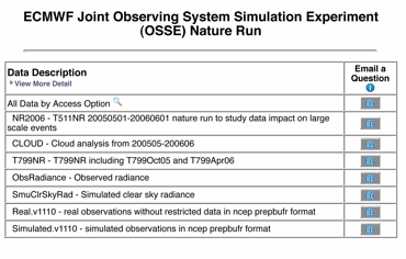
NCAR Dataset name: NR2006 and T799NR
NASA Portal: https://portal.nccs.nasa.gov/osse/
[Summary]
A broad group of US and international partners organized and agreed to have ECMWF compute a high resolution global gridded dataset that serves as a reference data set for general and collaborative observing system simulation experiments (OSSE). This model output is termed a “Nature Run”, because it is intended to be the best representation possible of the true environmental conditions. The temporal and spatial resolutions are sufficient so the data may be used as an experimental sample and validation data for planning future observing systems. It is especially valuable for assessing future satellite systems.
Summary
of the background of Joint OSSEs is posted at http://www.emc.ncep.noaa.gov/research/JointOSSEs/data/ECMWF_Joint_OSSE_NR.BackGround.html
Description of the complete data is posted at
http://www.emc.ncep.noaa.gov/research/JointOSSEs/data/ECMWF_Joint_OSSE_NR.Data_Description.html
[Usage and credit]
This data must not be used for commercial purposes. ECMWF and Joint OSSEs must be given credit in any publications in which this data is used. A user list will be tracked at NCAR and shared with ECMWF and Joint OSSE. Re-distribution rights have not been given.
If you are interested in using the data set, please send the following note by E-mail with your name and affiliation to Michiko Masutani at michiko.masutani@noaa.gov. Your name will be added to the user list and sent to ECMWF.
"I agree not to copy the ECMWF data or software provided by NCAR for use by other persons, and I agree not to use these data and/or software for commercial purposes. ECMWF will be given credit in any publications in which these data and/or software are used. I understand that if other persons in my organization wish to use these data and/or software, they must also sign a copy of this agreement."
[Data distribution]
The complete data for the T511NR, T799NR are saved at ECMWF, NCEP, NASA/NCCS, and ESRL. Model level data and surface data are saved as a reduced gaussian grid. Regular lat-lon gridded data for pressure levels, isentropic levels and surface data are also provided for verification purposes.
Access to the complete data are available through the NASA/GSFC/NCCS portal system.
http://portal.nccs.nasa.gov/osse/index.pl
Requires a user name and password.
Selected data are posted from NCAR as data ID=ds621.0
http://dss.ucar.edu/datasets/ds621.0/matrix.html
A.1 T511 Nature Run
interpolated to 1degx 1deg grid at
NCAR
NCAR :
NR2006
NASA Portal:
https://portal.nccs.nasa.gov/osse/T511NR_1x1_date/
Format: Grib 1
Type: regular lat lon grid
Update: as required
Frequency: 3 hourly
Coverage: global
[Data description in each directory]
/NR2006/
pl.date.links.tar
pt.date.links.tar
Expanding
these tar balls generates the directories pl.date.links
and pt.date.links and links for pl.date
and pt.date.
/NR2006/pl.tm
Verification data are provided for 1deg x 1deg for T511 NR
Time series in pressure level
Pressure
data in 1degx1deg
Time series at 1000 925 850 700 600 500 400 300 250 50 10
Dprs 155 Divergence [s**-1]
Tprs 130 Temperature
[K]
Uprs 131 U
velocity [m s**-1]
Vprs 132 V
velocity [m s**-1]
VOprs 138 Vorticity
(relative) [s**-1]
Zprs 129 Geopotential
[m**2 s**-2]
Wprs 135 Vertical
velocity [Pa s**-1]
Qprs 133 Specific
humidity [kg kg**-1]
/NR2006/pl.date
Verification data are provided for 1deg x 1deg for T511 NR
Pressure data at each time period
31 Pressure levels
1000
975 950 925 900 850 800 775 750 700 650 600 550 500 450 400 350 300 250 200 150
100 70 50 30 20 10 7 5 3 2 1
Variables
CCprs 248 Cloud cover [(0 -
1)]
CIWCprs
247 Cloud ice water
content [kg kg**-1]
CLWCprs
246 Cloud liquid
water content [kg kg**-1]
Dprs 155 Divergence
[s**-1]
O3prs 203 Ozone mass mixing
ratio [kg kg**-1]
Qprs 133 Specific humidity
[kg kg**-1]
Rprs 157 Relative humidity
[%]
Tprs 130 Temperature [K]
Uprs 131 U velocity [m
s**-1]
Vprs 132 V velocity [m
s**-1]
VOprs 138 Vorticity
(relative) [s**-1]
Wprs 135 Vertical velocity
[Pa s**-1]
Zprs 129 Geopotential
[m**2 s**-2]
/NR2006/pt.tm
Verification data are provided for 1deg x 1deg for T511 NR
Time series of Isentropic level data
Time series at 315,330,350,370,530
Dtht 155 Divergence
[s**-1]
MONTtht 53 Montgomery
potential [m**2 s**-2]
O3tht 203 Ozone mass mixing
ratio [kg kg**-1]
PREStht 54 Pressure
[Pa]
PVtht 60 Potential
vorticity [K m**2 kg**-1 s**-1]
Qtht 133 Specific humidity
[kg kg**-1]
Utht 131 U velocity [m
s**-1]
Vtht 132 V velocity [m
s**-1]
VOtht 138 Vorticity
(relative) [s**-1]
/NR2006/pt.date
Verification data are provided for 1deg x 1deg for T511 NR
Isentropic level data in each time period
Five potential temperature levels 315,330,350,370,530
Dtht 155 Divergence
[s**-1]
MONTtht 53 Montgomery
potential [m**2 s**-2]
O3tht 203 Ozone mass mixing
ratio [kg kg**-1]
PREStht 54 Pressure
[Pa]
PVtht 60 Potential
vorticity [K m**2 kg**-1 s**-1]
Qtht 133 Specific humidity
[kg kg**-1]
Utht 131 U velocity [m
s**-1]
Vtht 132 V velocity [m
s**-1]
VOtht 138 Vorticity
(relative) [s**-1]
/NR2006/sfc.tm
Verification data are provided for 1deg x 1deg for T511 NR
Time series of Surface data in 1degx1deg
U10m
165 10
metre U wind component [m s**-1]
V10m
166 10
metre V wind component [m s**-1]
TD2m
168 2 metre dewpoint temperature [K]
T2m
167 2 metre
temperature [K]
CP
143 Convective
precipitation [m]
HCC
188 High cloud cover [(0 - 1)]
LCC 186 Low cloud cover [(0 - 1)]
LSP 142 Stratiform precipitation [m]
MCC
187 Medium
cloud cover [(0 - 1)]
MSL
151 Mean sea-level pressure [Pa]
SKT
235 Skin temperature [K]
TCC
164 Total cloud cover [(0 - 1)]
SD
141 Snow depth [m of
water equivalent]
A.2 T799 Nature Run interpolated to 1.0 degx1.0 deg regular grid
NCAR: T799NR
T799 Nature Run pressure level data, surface data, isentropic data are provided on a 0.5degx0.5 deg regular grid. The data was reduced to1degx1deg when it was posted at NCAR.
Access to the complete data is available through the NASA/GSFC/NCCS portal system.
NASA NCCS (0.5 degx0.5deg)
http://portal.nccs.nasa.gov/osse/T799_autumn/prs05x05
http://portal.nccs.nasa.gov/osse/T799_spring/prs05x05
Time series
of 1degx1deg surface data are posted from NCAR.
T799NR/OCT05/tm_1by1
Verification data for T711NROct06
Time series of Surface data in 1degx1deg
T799NR/APR06/tm_1by1
Verification data for T722NRApr06
Time series of Surface data in 1degx1deg
U10m
165 10
metre U wind component [m s**-1]
V10m
166 10
metre V wind component [m s**-1]
TD2m
168 2 metre dewpoint temperature [K]
T2m
167 2 metre
temperature [K]
CP
143 Convective
precipitation [m]
HCC
188 High cloud cover [(0 - 1)]
LCC 186 Low cloud cover [(0 - 1)]
LSP 142 Stratiform precipitation [m]
MCC
187 Medium
cloud cover [(0 - 1)]
MSL
151 Mean sea-level pressure [Pa]
SKT
235 Skin temperature [K]
TCC
164 Total cloud cover [(0 - 1)]
SD
141 Snow depth [m of
water equivalent]
Orog
Orography in 1degx1deg at 12Z May 1 2005
NR2006/ml.date/200505
Sample Model level data for T511 NR
B. Real
and Simulated observation
B.1 Real radiance
data used for NCEP reanalysis
NCAR: ObsRadiance
NASA/NCCS : http://portal.nccs.nasa.gov/josse/NCEP_Obs/Rad.data.v4/templates
Types of radiance
data and locations used for the reanalysis from May 2005 – May 2006. Sensors and satellite are AIRS (Aqua), AMSU-A (Aqua, NOAA-15, 16, 18), AMSU-B (NOAA-15,
16,17), HIRS2
(NOAA 14), HIRS-3( NOAA 15,16,17),
HIRS-4 (NOAA-18), MSU (NOAA-14), MHS (NOAA-18) and the GOES sounder (GOES-10,
12). Data are provided for T511
Nature Run period: from May 2005 to May 2006. Data are saved in NCEP BUFR format.
B.2 Simulated radiance data
NCAR:
SmuClrSkyRad
NASA/NCCS:
http://portal.nccs.nasa.gov/josse/NCEP-NESDIS/SimRad.v4.201104/NC2005.bfr
Radiance data were simulated at same type of
data and location as real observation (ObsRadiance). The Community Radiative Tranfer Model 1.2.2 (CRTM 1.2.2) was used for simulations. Only clear sky
radiance data were simulated. This
is acceptable because most of the cloudy radiances were not used by the reanalysis. Cloudy radiance data were also simulated
but not posted for the public. For
cloudy radiances, please contact Michiko Masutani. Data are saved in NCEP BUFR format.
No observational error is added to the data. Development of observational error is being conducted at NASA/GMAO and NOAA/NESDIS-NCEP.
B.3 Real conventional data
NCAR: Real.v1110
NASA/NCCS:
http://portal.nccs.nasa.gov/josse/NCEP_prepbufr/real.v1110
Observations included in prepbufr data at NCEP reanalysis. Restricted data were removed.
B.4
Simulated conventional observation
NCAR: Simulated.v1110
NASA/NCCS: http://portal.nccs.nasa.gov/josse/NCEP_prepbufr/simulated.v1110
Simulated observations included in prepbufr data in the NCEP reanalysis. Same types of
observations and the same locations as used by the reanalysis. Location and types of restricted
data were removed. Cloud track wind
is based on real observation locations. No observational error was added.
C. Cloud
data
NCAR: CLOUD
Cloud/RTN
Air Force Nephanalysis Cloud Processed at NOAA/NCEP/EMC
References
Hamill, T. M., R. P. d'Entrement, and J. T. Bunting, 1992: A description of the Air Force real-time, nephanalysis model, Weather and Forecasting, 7, 288-306.
Henderson-Sellers, A. 1986: Layer cloud amount for January and July 1979 from 3D-Nephanalysis, J. Climate Appl. Meteor., 24, 118-132.
Frequency
of the data: 1 hour
All files are compressed and tared.
Each file cover
one hour and has five records
dd,mm,yy,TCC,hh
dd,mm,yy,HCC,hh
dd,mm,yy,MCC,hh
dd,mm,yy,LCC,hh
dd,mm,yy,BCC,hh
TCC,HCC,MCC,LCC,BCC are written in 32 bits big endian real.
Array of (361,181).
0E is repeated.
255.0 for missing data. dd,mm,yy,hh
are integer.
Cloud/CLAVRX
Cloud from AVHRR Extended
(CLAVR-x) produced by NOAA/NESDIS processed by
NOAA/NCEP/EMC
http://cimss.ssec.wisc.edu/clavr/
Contact:
NESDIS Andrew Heidinger
andrew.heidinger@noaa.gov
format: Grib 1
Frequency: 6 hourly
Missing period
June 2005 data is missing from the data sent to NCAR
Please down load from
ftp://ftp.emc.ncep.noaa.gov/exper/mmasutani/cloud/RTN/jun05.WWMCA1deg
I need to find good reference for RTN cloud and CLAVRX clou