 First
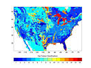
Most Predominant Surface Soil Classes Over NLDAS Domain
First
Most Predominant Surface Soil Classes Over NLDAS Domain 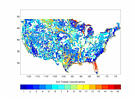 Second Most Predominant Surface Soil Classes
Over NLDAS Domain
Second Most Predominant Surface Soil Classes
Over NLDAS Domain
      read(10,40) ((isoil(i,j),i=1,464),j=1,224)
40    format(464i3))
 Layer 1 Data (TXDM1_01.GRD)
Layer 2 Data (TXDM1_02.GRD)
Layer 3 Data (TXDM1_03.GRD)
Layer 4 Data (TXDM1_04.GRD)
Layer 5 Data (TXDM1_05.GRD)
Layer 6 Data (TXDM1_06.GRD)
Layer 7 Data (TXDM1_07.GRD)
Layer 8 Data (TXDM1_08.GRD)
Layer 9 Data (TXDM1_09.GRD)
Layer 10 Data (TXDM1_10.GRD)
Layer 11 Data (TXDM1_11.GRD)
Layer 1 Data (TXDM1_01.GRD)
Layer 2 Data (TXDM1_02.GRD)
Layer 3 Data (TXDM1_03.GRD)
Layer 4 Data (TXDM1_04.GRD)
Layer 5 Data (TXDM1_05.GRD)
Layer 6 Data (TXDM1_06.GRD)
Layer 7 Data (TXDM1_07.GRD)
Layer 8 Data (TXDM1_08.GRD)
Layer 9 Data (TXDM1_09.GRD)
Layer 10 Data (TXDM1_10.GRD)
Layer 11 Data (TXDM1_11.GRD)
      read(10,40) ((pcnt(i,j),i=1,464),j=1,224)
40    format(464f5.0)
Percentage of First Most Predominant Soil Texture Class in Surface Layer (pcnts_1.grd) Percentage of Second Most Predominant Soil Texture Class in Surface Layer (pcnts_2.grd) | Column 1 | X Coordinate Index | |
| Column 2 | Y Coordinate Index | |
| Column 3 | Longitude | |
| Column 4 | Latitude | |
| Columns 5-21 | Number of Occurrences of Soil
Classes 1-16 in Each 1/8th Grid Box |
            read (20, 100) ix,iy,xlon,ylat,(iclass(j),j=1,16)
  100       format (2i4,1x,f9.4,f8.4,20i4)
Layer 1 Data (stex_tab.01)
Layer 2 Data (stex_tab.02)
Layer 3 Data (stex_tab.03)
Layer 4 Data (stex_tab.04)
Layer 5 Data (stex_tab.05)
Layer 6 Data (stex_tab.06)
Layer 7 Data (stex_tab.07)
Layer 8 Data (stex_tab.08)
Layer 9 Data (stex_tab.09)
Layer 10 Data (stex_tab.10)
Layer 11 Data (stex_tab.11)
| Column 1 | X Coordinate Index | |
| Column 2 | Y Coordinate Index | |
| Column 3 | Longitude | |
| Column 4 | Latitude | |
| Columns 5 | Number of Inland Water Points in Each 1/8th Degree Pixel | |
| Columns 6 | Number of Bedrock Points in Each 1/8th Degree Pixel | |
| Columns 7 | Number of Missing or Ocean Points in Each 1/8th Degree Pixel | |
| Columns 8 | Number of Soil Classifications
(Excluding Bedrock, Ocean and Missing Points) in each 1/8th Degree Pixel | |
| Columns 9-10 | The First Most Dominant Classification and the
Corresponding Number of Occurences in Each 1/8th Degree Pixel | |
| Columns 11-12 | The Second Most Dominant Classification and the
Corresponding Number of Occurences in Each 1/8th Degree Pixel |
            read (10, 200) ix,iy,xlon,ylat,nwat,nroc,nmis,ncl,
     +           (icl(j),mcl(j),j=ncl,1,-1)
  200       format(2i4,1x,f9.4,f8.4,20i4)
Layer 1 Data (SOILTEXT.01)
Layer 2 Data (SOILTEXT.02)
Layer 3 Data (SOILTEXT.03)
Layer 4 Data (SOILTEXT.04)
Layer 5 Data (SOILTEXT.05)
Layer 6 Data (SOILTEXT.06)
Layer 7 Data (SOILTEXT.07)
Layer 8 Data (SOILTEXT.08)
Layer 9 Data (SOILTEXT.09)
Layer 10 Data (SOILTEXT.10)
Layer 11 Data (SOILTEXT.11)
| Column 1 | X Coordinate Index | |
| Column 2 | Y Coordinate Index | |
| Column 3 | Longitude | |
| Column 4 | Latitude | |
| Columns 5 | Porosity (%) | |
| Columns 6 | Field Capacity (%) | |
| Columns 7 | Wilting Point (%) | |
| Columns 8 | B Parameter | |
| Columns 9 | Saturated Soil Matric Potential (in m of H2O) | |
| Columns 10 | Saturated Soil Hydraulic Conductivity (in m/s) |
Soil hydraulic properties data set based on Cosby's numbers except Ksat, which is based on Rawls' work.
            read (20, 200) ic,ir,xlon,ylat,xporos,xfldcp,xwltpt,
     x                     xb,xpsi50,xks50
  200       format(2i4,1x,f9.4,f8.4,5f9.3,e11.3)
Layer 1 Data (COS_RAWL.01)
Layer 2 Data (COS_RAWL.02)
Layer 3 Data (COS_RAWL.03)
Layer 4 Data (COS_RAWL.04)
Layer 5 Data (COS_RAWL.05)
Layer 6 Data (COS_RAWL.06)
Layer 7 Data (COS_RAWL.07)
Layer 8 Data (COS_RAWL.08)
Layer 9 Data (COS_RAWL.09)
Layer 10 Data (COS_RAWL.10)
Layer 11 Data (COS_RAWL.11)
Layer 1 Data (HYD_CLAP.01)
Layer 2 Data (HYD_CLAP.02)
Layer 3 Data (HYD_CLAP.03)
Layer 4 Data (HYD_CLAP.04)
Layer 5 Data (HYD_CLAP.05)
Layer 6 Data (HYD_CLAP.06)
Layer 7 Data (HYD_CLAP.07)
Layer 8 Data (HYD_CLAP.08)
Layer 9 Data (HYD_CLAP.09)
Layer 10 Data (HYD_CLAP.10)
Layer 11 Data (HYD_CLAP.11)
Layer 1 Data (HYD_COSB.01)
Layer 2 Data (HYD_COSB.02)
Layer 3 Data (HYD_COSB.03)
Layer 4 Data (HYD_COSB.04)
Layer 5 Data (HYD_COSB.05)
Layer 6 Data (HYD_COSB.06)
Layer 7 Data (HYD_COSB.07)
Layer 8 Data (HYD_COSB.08)
Layer 9 Data (HYD_COSB.09)
Layer 10 Data (HYD_COSB.10)
Layer 11 Data (HYD_COSB.11)
Layer 1 Data (HYD_RAWL.01)
Layer 2 Data (HYD_RAWL.02)
Layer 3 Data (HYD_RAWL.03)
Layer 4 Data (HYD_RAWL.04)
Layer 5 Data (HYD_RAWL.05)
Layer 6 Data (HYD_RAWL.06)
Layer 7 Data (HYD_RAWL.07)
Layer 8 Data (HYD_RAWL.08)
Layer 9 Data (HYD_RAWL.09)
Layer 10 Data (HYD_RAWL.10)
Layer 11 Data (HYD_RAWL.11)
 |
 |
NLDAS Web Page
Maintained and Updated at NOAA/NCEP/EMC |
Kenneth Mitchell: Kenneth.Mitchell@noaa.gov
Youlong Xia: Youlong.Xia@noaa.gov |
 |