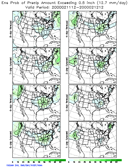
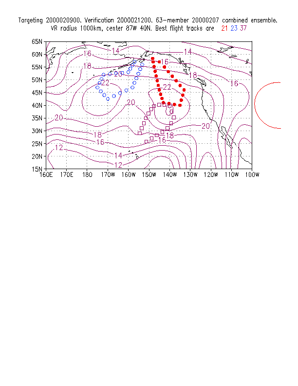
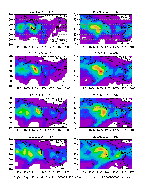
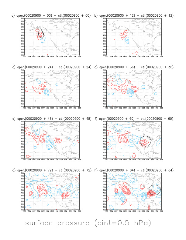
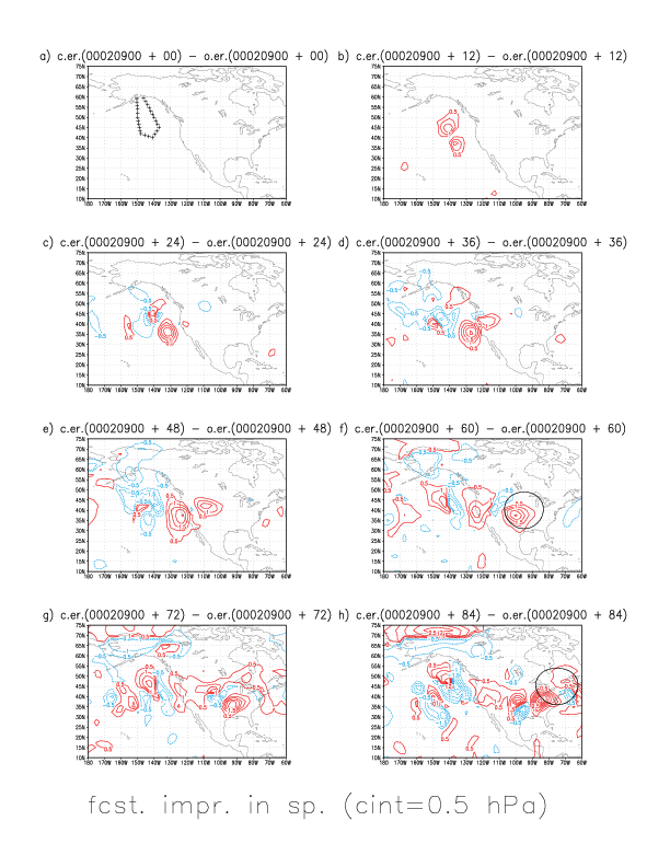
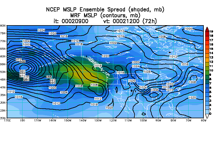
Given that the 5-day forecast initialized at 020700 gave around 50% probability of more than half inch of precipitation associated with this storm, HPC requested that adaptive observations be taken in order to reduce the large uncertainty associated with the above forecast feature (see attached text below). Due to the long advance notice required by Air Traffic Control before dropsondes can be released from any aircraft, flight planning for a 020900 flight had to be prepared on 0207. Given the verification times and locations in the HPC request, sensitivity calcuations were carried out to determine the area from where data taken around 020900 can most inmfluence the selected forecast feature. The sensitivity chart indicates that on this day a large area extending from 175E to 120W, and from 35 to 50N is highly relevant for downstream forecasts verifying around 40N, 87W, 3 days later. The 2-day forecast initialized at 020700 indicated that the two most sensitive areas are associated with a very deep low pressure system west of the dateline, and a small, shallow low pressure wave around 140W. Of the two maxima reachable from Anchorage with the available NOAA G-lV plane, the eastern one (around 37N, 140W) was estimated more important. The sensitivity technique also provides an estimate how the data can be expected to influence the forecasts. The estimated data impact chart should be evaluated only in a qualitative way. It indicates the impact of the data would travel slowly to the east, reaching the west coast within 36 hrs; and larger impact over the eastern half of the continent can be expected around 72-84 hrs lead times. We can compare the predicted data impact chart to the actual impact of the data, determined as the difference between two independently run analysis/forecast cycles. The actual signal evolved similarly to what was predicted and the data had a large impact in the preselected verification areas/times. Much of this impact was positive. The red contours on the comparative verification chart indicate that forecast errors were reduced due to the use of the adaptive data, while the blue contours over smaller areas indicate an increase in forecast errors. Overall, the 72-hour forecast initialized using all operationally available - including targeted - data, provided a much improved guidance compared to the 120-hour forecast, indicating that there would be two low pressure systems following each other along similar paths, and that the verification area around 021200, around 40N, 87W would be dominated by a high pressure system between the two low pressure systems.
HPC REQUEST
HIGH IMPACT WEATHER EVENTS WITH
LARGE FORECAST UNCERTAINTY
REQUIRING ADDITIONAL OBSERVATIONS
WSR2000
Zoltan,
Here are todays's key areas. They may look a bit redundant, but you
can
vary by as much as a day a flight with the same weather system to
maximize logistics.
Priority VT Area Remarks
High
021112 40N/95W
Central US system highly
uncertain
in
medium range models.
High
021212 45N/75W
Same system as above...24
hrs later.
Medium 021300
40N/120W Broad area of spread NOAM
W
coast
Medium 021300
50N/135W Second max within same broad
area
Addendum:
021200 42N 125W
west coast precip event (low)
021400 42N 97W
possible second low pressure wave affecting eastern US
(low)
ZT