The expected reliability of weather forecasts shows drastic variations depending on the daily flow configuration. On certain days a 10-day forecast may have highly predictable features in it; on other days a 3-day forecast may have features which have very little or no predictability. Ensemble forecasts can identify at the time a forecast is prepared how much predictability a particular weather feature has, given the initial uncertainty in the analysis and the time evolution of the possible atmospheric states up to a particular lead time of interest.
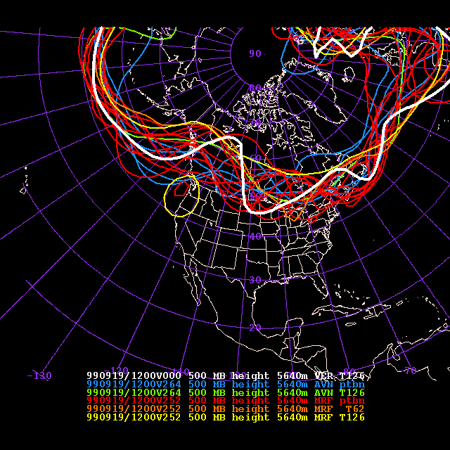
In the example shown below all three spaghetti forecasts are valid on the same day, 1999 Sept 19, 1200 UTC time. The heavy white line that repeats on all figures is the verifying analysis. The first forecast shown has a lead time of 252 hrs and indicates that at this lead time predictability is limited to certain areas (like over the Pacific where all members agree that a strong zonal flow would prevail). Also, there is an indication for a high pressure system over western north America (most members suggest this, but the exact location of the axis of the ridge is uncertain; some members also indicate that a cutoff low may develop over the northeast coast - this feature did not verify). Also, most members indicate a low pressure system over the eastern Atlantic (though the trough's depth varies among the members). There is complete disagreement among the members, however, regarding the flow over the middle and eastern part of NA. The forecasts suggest though that the flow will likely be amplified there (large-scale waves will develop, which may have predictive value to some users) but the timing/location of the waves is not predictable at this lead time. In summary, different weather features possess varying degree of predictability, which can be revealed by a careful study of spaghetti and other (not shown) ensemble products.
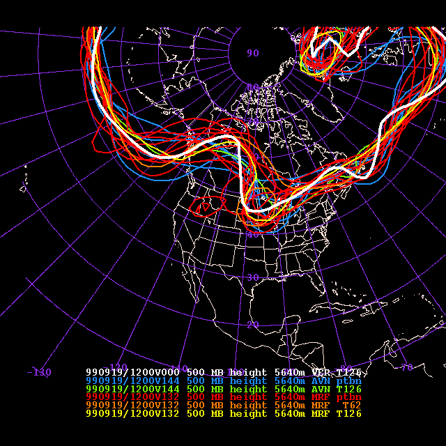
At 132 hrs lead time the main, larger scale features of the observed flow are well captured by the ensemble. The location of the ridge over western north America, and the depth of the trough over the eastern Atlantic are much better defined, and there is a clear indication for a trough in the middle portion of the NA continent. In general, there is much less disagreement among the members than at the longer lead time - this is because the shorter forecast time period allows less forecast uncertainty to develop, resulting in a forecast with a much higher information content. Nevertheless there are significant differences among the members on the synoptic scales. A notable example of this is the expected flow over Nova Scotia. The ensemble indicates the possibility of a smaller scale trough there but other members suggest with equal likelihood that a ridge or more zonal flow may develop as well.
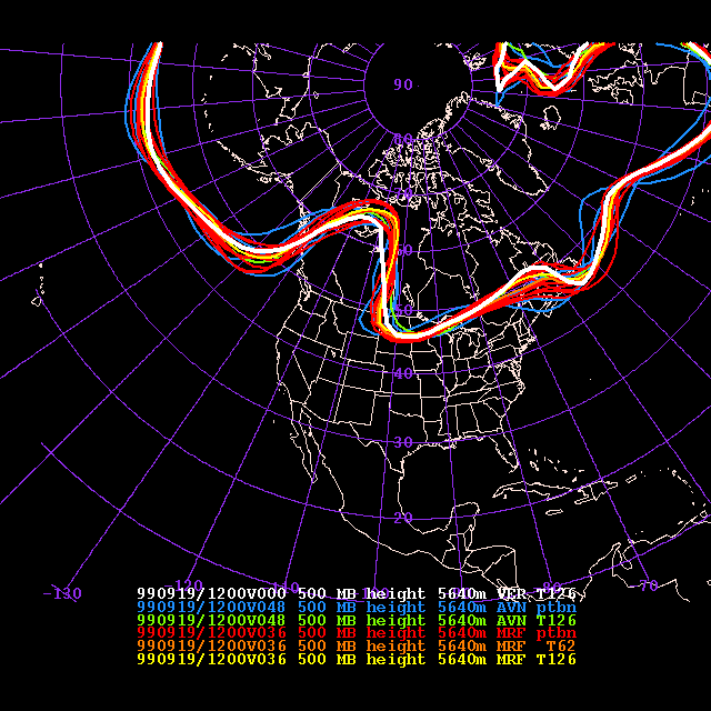
At 36 hrs lead time, the spread among the ensemble members is further reduced. Most features exhibit high predictability and the verifying analysis is typically within the narrow range of ensemble members. The flow west of Nova Scotia, however, still exhibits a lot of uncertainty. Most members indicate a small-scale ridge in this area (and this, majority scenario verified) but a few members suggest the possibility of cyclonic circulation.